
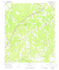
~ Cannonville GA topo map, 1:24000 scale, 7.5 X 7.5 Minute, Historical, 1964, updated 1974
Cannonville, Georgia, USGS topographic map dated 1964.
Includes geographic coordinates (latitude and longitude). This topographic map is suitable for hiking, camping, and exploring, or framing it as a wall map.
Printed on-demand using high resolution imagery, on heavy weight and acid free paper, or alternatively on a variety of synthetic materials.
Topos available on paper, Waterproof, Poly, or Tyvek. Usually shipping rolled, unless combined with other folded maps in one order.
- Product Number: USGS-5360946
- Free digital map download (high-resolution, GeoPDF): Cannonville, Georgia (file size: 9 MB)
- Map Size: please refer to the dimensions of the GeoPDF map above
- Weight (paper map): ca. 55 grams
- Map Type: POD USGS Topographic Map
- Map Series: HTMC
- Map Verison: Historical
- Cell ID: 7079
- Scan ID: 245234
- Imprint Year: 1974
- Woodland Tint: Yes
- Photo Revision Year: 1973
- Aerial Photo Year: 1973
- Datum: NAD27
- Map Projection: Polyconic
- Map published by United States Geological Survey
- Map Language: English
- Scanner Resolution: 600 dpi
- Map Cell Name: Cannonville
- Grid size: 7.5 X 7.5 Minute
- Date on map: 1964
- Map Scale: 1:24000
- Geographical region: Georgia, United States
Neighboring Maps:
All neighboring USGS topo maps are available for sale online at a variety of scales.
Spatial coverage:
Topo map Cannonville, Georgia, covers the geographical area associated the following places:
- Pioneer Village - Colonial Heights - South Pine Ranchettes - Old Chimney - Bartley Road Estates - Plantation Manor - Hogg Mountain - West Wood - Smoke Rise - Smiths Crossroad - Cottons Crossroads - Parkway Estates - Cannonville - Raby Woods - Wood Valley - Baughs Crossroads - Federal Hills - Gray Hill - Maplecreek Hills
- Map Area ID: AREA3332.875-85.125-85
- Northwest corner Lat/Long code: USGSNW33-85.125
- Northeast corner Lat/Long code: USGSNE33-85
- Southwest corner Lat/Long code: USGSSW32.875-85.125
- Southeast corner Lat/Long code: USGSSE32.875-85
- Northern map edge Latitude: 33
- Southern map edge Latitude: 32.875
- Western map edge Longitude: -85.125
- Eastern map edge Longitude: -85


