
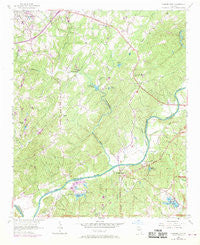
~ Campbellton GA topo map, 1:24000 scale, 7.5 X 7.5 Minute, Historical, 1954, updated 1969
Campbellton, Georgia, USGS topographic map dated 1954.
Includes geographic coordinates (latitude and longitude). This topographic map is suitable for hiking, camping, and exploring, or framing it as a wall map.
Printed on-demand using high resolution imagery, on heavy weight and acid free paper, or alternatively on a variety of synthetic materials.
Topos available on paper, Waterproof, Poly, or Tyvek. Usually shipping rolled, unless combined with other folded maps in one order.
- Product Number: USGS-5360942
- Free digital map download (high-resolution, GeoPDF): Campbellton, Georgia (file size: 12 MB)
- Map Size: please refer to the dimensions of the GeoPDF map above
- Weight (paper map): ca. 55 grams
- Map Type: POD USGS Topographic Map
- Map Series: HTMC
- Map Verison: Historical
- Cell ID: 6970
- Scan ID: 245230
- Imprint Year: 1969
- Woodland Tint: Yes
- Photo Revision Year: 1968
- Aerial Photo Year: 1968
- Datum: NAD27
- Map Projection: Polyconic
- Map published by United States Geological Survey
- Map Language: English
- Scanner Resolution: 600 dpi
- Map Cell Name: Campbellton
- Grid size: 7.5 X 7.5 Minute
- Date on map: 1954
- Map Scale: 1:24000
- Geographical region: Georgia, United States
Neighboring Maps:
All neighboring USGS topo maps are available for sale online at a variety of scales.
Spatial coverage:
Topo map Campbellton, Georgia, covers the geographical area associated the following places:
- Anneewakee Estates - Dorris - Stewart Woods - The Meadows North - Western Pines - Anneewakee - Britt - Springwood Village - Ivey Estates - Captains Quarters - South Ridge - Chapel Hill - Cedar Grove - Southern Manor - Douglas Estates - Dogwood Acres - Five Notch Acres - Hyde Park - Blair Heights - Whispering Woods Estates - Campbellton - Heritage Valley - Meadowview - Creek Indian - Glen Villa - Alta Vista - Doublegate - Shawnee Lake Estates - Carmel Chase - Brown Subdivision - Holland Manor - Springhill Estates - Windwood Village - Flowers Estates - Warren Heights - Del Ridge - Hilderbrand - Mecca (historical) - Timber Valley - Longview Estates - Evergreen - Chestnut Log - Daniel Subdivision - Salem - Rebel Trail - Tara Woods - Carmel Farms - Flagview Mobile Home Park - Reynolds Estates - Anneewakee Heights - Rolling Hills - Corn Creek Cove - Shelby Forest
- Map Area ID: AREA33.7533.625-84.75-84.625
- Northwest corner Lat/Long code: USGSNW33.75-84.75
- Northeast corner Lat/Long code: USGSNE33.75-84.625
- Southwest corner Lat/Long code: USGSSW33.625-84.75
- Southeast corner Lat/Long code: USGSSE33.625-84.625
- Northern map edge Latitude: 33.75
- Southern map edge Latitude: 33.625
- Western map edge Longitude: -84.75
- Eastern map edge Longitude: -84.625


