
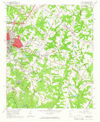
~ Athens East GA topo map, 1:24000 scale, 7.5 X 7.5 Minute, Historical, 1964, updated 1966
Athens East, Georgia, USGS topographic map dated 1964.
Includes geographic coordinates (latitude and longitude). This topographic map is suitable for hiking, camping, and exploring, or framing it as a wall map.
Printed on-demand using high resolution imagery, on heavy weight and acid free paper, or alternatively on a variety of synthetic materials.
Topos available on paper, Waterproof, Poly, or Tyvek. Usually shipping rolled, unless combined with other folded maps in one order.
- Product Number: USGS-5360426
- Free digital map download (high-resolution, GeoPDF): Athens East, Georgia (file size: 11 MB)
- Map Size: please refer to the dimensions of the GeoPDF map above
- Weight (paper map): ca. 55 grams
- Map Type: POD USGS Topographic Map
- Map Series: HTMC
- Map Verison: Historical
- Cell ID: 1753
- Scan ID: 244933
- Imprint Year: 1966
- Woodland Tint: Yes
- Aerial Photo Year: 1962
- Field Check Year: 1964
- Datum: NAD27
- Map Projection: Polyconic
- Map published by United States Geological Survey
- Map Language: English
- Scanner Resolution: 600 dpi
- Map Cell Name: Athens East
- Grid size: 7.5 X 7.5 Minute
- Date on map: 1964
- Map Scale: 1:24000
- Geographical region: Georgia, United States
Neighboring Maps:
All neighboring USGS topo maps are available for sale online at a variety of scales.
Spatial coverage:
Topo map Athens East, Georgia, covers the geographical area associated the following places:
- Waverly Woods - Eastmeadow - University Heights - Cedar Creek - Winter Hills - Barch Estates - River Hill East - Spring Valley Estates - Crestwood Estates - Greenmont - Weatherly Woods - Lexington Estates - Clarkedale - Red Fox - Rock and Shoals - Overlook Lake - Hunters Ridge - Carriage Hills - Snapfinger - Waterford - Shoal Creek - Ansley Park - Shadow Moss - Green Acres - Unified Government of Athens-Clarke County (Balance) - Windfall Heights - Shoalsview - Lexington Heights - Chamberlin - Stonemill Run - Plantation Estates - Park East - Winterville - Shoal Creek Farms - Dunlap - The Jockey Club Estates - Lakewood - Cedar Bluff - West Winter - Whitehall - Glen Forest Mobile Home Park - Ashton Place - Wakefield Mobile Home Park - Riverbend East - Brookstone - Lakeside Hills - Wonderland Estates - Cedar Shoals Estates
- Map Area ID: AREA3433.875-83.375-83.25
- Northwest corner Lat/Long code: USGSNW34-83.375
- Northeast corner Lat/Long code: USGSNE34-83.25
- Southwest corner Lat/Long code: USGSSW33.875-83.375
- Southeast corner Lat/Long code: USGSSE33.875-83.25
- Northern map edge Latitude: 34
- Southern map edge Latitude: 33.875
- Western map edge Longitude: -83.375
- Eastern map edge Longitude: -83.25


