
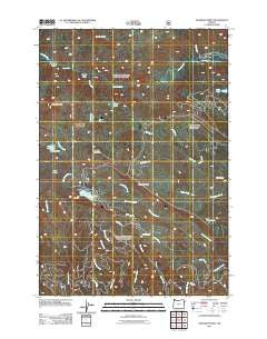
~ Deadman Point OR topo map, 1:24000 scale, 7.5 X 7.5 Minute, Historical, 2011
Deadman Point, Oregon, USGS topographic map dated 2011.
Includes geographic coordinates (latitude and longitude). This topographic map is suitable for hiking, camping, and exploring, or framing it as a wall map.
Printed on-demand using high resolution imagery, on heavy weight and acid free paper, or alternatively on a variety of synthetic materials.
Topos available on paper, Waterproof, Poly, or Tyvek. Usually shipping rolled, unless combined with other folded maps in one order.
- Product Number: USGS-5360220
- Free digital map download (high-resolution, GeoPDF): Deadman Point, Oregon (file size: 24 MB)
- Map Size: please refer to the dimensions of the GeoPDF map above
- Weight (paper map): ca. 55 grams
- Map Type: POD USGS Topographic Map
- Map Series: US Topo
- Map Verison: Historical
- Cell ID: 69840
- Datum: North American Datum of 1983
- Map Projection: Transverse Mercator
- Map Cell Name: Deadman Point
- Grid size: 7.5 X 7.5 Minute
- Date on map: 2011
- Map Scale: 1:24000
- Geographical region: Oregon, United States
Neighboring Maps:
All neighboring USGS topo maps are available for sale online at a variety of scales.
Spatial coverage:
Topo map Deadman Point, Oregon, covers the geographical area associated the following places:
- Lick Creek - Sugarloaf Reservoir - Buchanan Ditch - Duck Lake - Greener Ditch - Gobblers Knob - Warm Lake - Aspen Creek - Pole Creek - Lake Frances - Fish Lake Dam - Deadman Point - Moody Basin - Lost Lake Reservoir - Twin Lakes Recreation Site - Indian Crossing - Sugarloaf Dam - Cabin Creek - Trinity Guard Station - Deadman Canyon - Horse Lake - Rock Creek - Twin Lakes - Huff Ditch - West Trinity Creek - Fish Lake Recreation Site - Pole Creek - Indian Crossing Recreation Site - Big Elk Creek - Mud Lake - Fish Lake Guard Station - Fish Lake - Fish Lake Campground Boat Launch - East Trinity Creek - Imnaha Falls - Fish Lake Branch - Russel Mountain
- Map Area ID: AREA45.12545-117.125-117
- Northwest corner Lat/Long code: USGSNW45.125-117.125
- Northeast corner Lat/Long code: USGSNE45.125-117
- Southwest corner Lat/Long code: USGSSW45-117.125
- Southeast corner Lat/Long code: USGSSE45-117
- Northern map edge Latitude: 45.125
- Southern map edge Latitude: 45
- Western map edge Longitude: -117.125
- Eastern map edge Longitude: -117


