
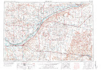
~ Sterling CO topo map, 1:250000 scale, 1 X 2 Degree, Historical, 1954
Sterling, Colorado, USGS topographic map dated 1954.
Includes geographic coordinates (latitude and longitude). This topographic map is suitable for hiking, camping, and exploring, or framing it as a wall map.
Printed on-demand using high resolution imagery, on heavy weight and acid free paper, or alternatively on a variety of synthetic materials.
Topos available on paper, Waterproof, Poly, or Tyvek. Usually shipping rolled, unless combined with other folded maps in one order.
- Product Number: USGS-5359839
- Free digital map download (high-resolution, GeoPDF): Sterling, Colorado (file size: 21 MB)
- Map Size: please refer to the dimensions of the GeoPDF map above
- Weight (paper map): ca. 55 grams
- Map Type: POD USGS Topographic Map
- Map Series: HTMC
- Map Verison: Historical
- Cell ID: 69038
- Scan ID: 234559
- Woodland Tint: Yes
- Aerial Photo Year: 1973
- Edit Year: 1976
- Field Check Year: 1954
- Datum: Unstated
- Map Projection: Transverse Mercator
- Map published by United States Geological Survey
- Map Language: English
- Scanner Resolution: 600 dpi
- Map Cell Name: Sterling
- Grid size: 1 X 2 Degree
- Date on map: 1954
- Map Scale: 1:250000
- Geographical region: Colorado, United States
Neighboring Maps:
All neighboring USGS topo maps are available for sale online at a variety of scales.
Spatial coverage:
Topo map Sterling, Colorado, covers the geographical area associated the following places:
- Buckingham - Clarkville - Twelvemile Corner - Lone Star - Lamb - Twin Mills - Snyder - Union - Dailey - Fort Morgan - Gary - Sterling - Paoli - Fort Sedgwick (historical) - Wray - Otis - Crook - Calhoun - Willard - Avalo - Iliff - Westplains - Burdett - Alvin - Hillrose - Pinneo - Hurley - Julesburg - Galien - Fort Julesburg (historical) - Haxtun - Padroni - Cooper - Proctor - Laird - Peetz - Camden - Buchanan - Moseley - Sedgwick - Venango - Xenia - Marcott - Schramm - Ovid - Hyde - Wauneta - New Raymer - Lodi - Log Lane Village - Red Lion - Leroy - Akron - Rago - Platner - Atwood - Rockland - Eckley - Logan - Brush - Saint Petersburg - Jessica - Amherst - Weldona - Dodd - Ninemile Corner - Fleming - Merino - Yuma - Griff - Stoneham - Robb - Adena - Messex - Tobin - Sanborn - Midway - Beta - Nelson - Ninemile Corner - Holyoke - Balzac - Selma - Raymer - New Haven
- Map Area ID: AREA4140-104-102
- Northwest corner Lat/Long code: USGSNW41-104
- Northeast corner Lat/Long code: USGSNE41-102
- Southwest corner Lat/Long code: USGSSW40-104
- Southeast corner Lat/Long code: USGSSE40-102
- Northern map edge Latitude: 41
- Southern map edge Latitude: 40
- Western map edge Longitude: -104
- Eastern map edge Longitude: -102


