
~ Cortez CO topo map, 1:250000 scale, 1 X 2 Degree, Historical, 1956, updated 1979
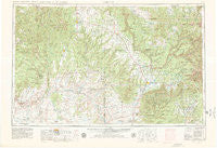
Cortez, Colorado, USGS topographic map dated 1956.
Includes geographic coordinates (latitude and longitude). This topographic map is suitable for hiking, camping, and exploring, or framing it as a wall map.
Printed on-demand using high resolution imagery, on heavy weight and acid free paper, or alternatively on a variety of synthetic materials.
Topos available on paper, Waterproof, Poly, or Tyvek. Usually shipping rolled, unless combined with other folded maps in one order.
- Product Number: USGS-5359681
- Free digital map download (high-resolution, GeoPDF): Cortez, Colorado (file size: 14 MB)
- Map Size: please refer to the dimensions of the GeoPDF map above
- Weight (paper map): ca. 55 grams
- Map Type: POD USGS Topographic Map
- Map Series: HTMC
- Map Verison: Historical
- Cell ID: 68731
- Scan ID: 403068
- Imprint Year: 1979
- Woodland Tint: Yes
- Aerial Photo Year: 1955
- Edit Year: 1969
- Field Check Year: 1956
- Datum: NAD27
- Map Projection: Transverse Mercator
- Map published by United States Geological Survey
- Map Language: English
- Scanner Resolution: 508 dpi
- Map Cell Name: Cortez
- Grid size: 1 X 2 Degree
- Date on map: 1956
- Map Scale: 1:250000
- Geographical region: Colorado, United States
Neighboring Maps:
All neighboring USGS topo maps are available for sale online at a variety of scales.
Spatial coverage:
Topo map Cortez, Colorado, covers the geographical area associated the following places:
- Montezuma Creek - Weber - Bluff - Dunton - Blanding - Mayday - Westerner Trailer Park - Swallows Nest (historical) - Rico - Northdale - Tselakai Dezza - Monticello - Millwood - Lewis - Marvel - Sawpit - Egnar - Mariano - Hesperus - Lebanon - Red Lake Village - Aneth - Breen - Dolores - Halchita - Stapleton - La Plata - Pleasant View - Indian Village - Mexican Hat - Eastland - White Rock Curve Village - Towaoc - White Mesa Village - Kline - Yellow Jacket - Verdure - Mancos - Stoner - Echo House (historical) - Roundup Junction - Dove Creek - Badger House Community (historical) - Arriola - Cortez - Little Water - Golconda - Rowleys Trailer Park - White Mesa - Redmesa - Cahone - Ucolo
- Map Area ID: AREA3837-110-108
- Northwest corner Lat/Long code: USGSNW38-110
- Northeast corner Lat/Long code: USGSNE38-108
- Southwest corner Lat/Long code: USGSSW37-110
- Southeast corner Lat/Long code: USGSSE37-108
- Northern map edge Latitude: 38
- Southern map edge Latitude: 37
- Western map edge Longitude: -110
- Eastern map edge Longitude: -108


