
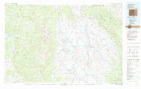
~ Walden CO topo map, 1:100000 scale, 30 X 60 Minute, Historical, 1981, updated 1982
Walden, Colorado, USGS topographic map dated 1981.
Includes geographic coordinates (latitude and longitude). This topographic map is suitable for hiking, camping, and exploring, or framing it as a wall map.
Printed on-demand using high resolution imagery, on heavy weight and acid free paper, or alternatively on a variety of synthetic materials.
Topos available on paper, Waterproof, Poly, or Tyvek. Usually shipping rolled, unless combined with other folded maps in one order.
- Product Number: USGS-5359093
- Free digital map download (high-resolution, GeoPDF): Walden, Colorado (file size: 17 MB)
- Map Size: please refer to the dimensions of the GeoPDF map above
- Weight (paper map): ca. 55 grams
- Map Type: POD USGS Topographic Map
- Map Series: HTMC
- Map Verison: Historical
- Cell ID: 68539
- Scan ID: 403063
- Imprint Year: 1982
- Woodland Tint: Yes
- Aerial Photo Year: 1977
- Edit Year: 1981
- Datum: NAD27
- Map Projection: Universal Transverse Mercator
- Map published by United States Geological Survey
- Map Language: English
- Scanner Resolution: 508 dpi
- Map Cell Name: Walden
- Grid size: 30 X 60 Minute
- Date on map: 1981
- Map Scale: 1:100000
- Geographical region: Colorado, United States
Neighboring Maps:
All neighboring USGS topo maps are available for sale online at a variety of scales.
Spatial coverage:
Topo map Walden, Colorado, covers the geographical area associated the following places:
- Clark - Coalmont - Slavonia - Gould - Fort Boettcher - Columbine - Pearl - Steamboat II - Walden - Cowdrey - Mystic - Kings Canyon - Stelbars Lindland - Mad Creek - Old Roach - Northgate - Larand - Glen Eden - Hebron - Brownlee
- Map Area ID: AREA4140.5-107-106
- Northwest corner Lat/Long code: USGSNW41-107
- Northeast corner Lat/Long code: USGSNE41-106
- Southwest corner Lat/Long code: USGSSW40.5-107
- Southeast corner Lat/Long code: USGSSE40.5-106
- Northern map edge Latitude: 41
- Southern map edge Latitude: 40.5
- Western map edge Longitude: -107
- Eastern map edge Longitude: -106


