
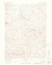
~ Rabbit Ears Peak CO topo map, 1:62500 scale, 15 X 15 Minute, Historical, 1956, updated 1970
Rabbit Ears Peak, Colorado, USGS topographic map dated 1956.
Includes geographic coordinates (latitude and longitude). This topographic map is suitable for hiking, camping, and exploring, or framing it as a wall map.
Printed on-demand using high resolution imagery, on heavy weight and acid free paper, or alternatively on a variety of synthetic materials.
Topos available on paper, Waterproof, Poly, or Tyvek. Usually shipping rolled, unless combined with other folded maps in one order.
- Product Number: USGS-5358811
- Free digital map download (high-resolution, GeoPDF): Rabbit Ears Peak, Colorado (file size: 5 MB)
- Map Size: please refer to the dimensions of the GeoPDF map above
- Weight (paper map): ca. 55 grams
- Map Type: POD USGS Topographic Map
- Map Series: HTMC
- Map Verison: Historical
- Cell ID: 61407
- Scan ID: 402586
- Imprint Year: 1970
- Edit Year: 1969
- Survey Year: 1968
- Datum: NAD27
- Map Projection: Polyconic
- Map published by United States Geological Survey
- Map Language: English
- Scanner Resolution: 508 dpi
- Map Cell Name: Rabbit Ears Peak
- Grid size: 15 X 15 Minute
- Date on map: 1956
- Map Scale: 1:62500
- Geographical region: Colorado, United States
Neighboring Maps:
All neighboring USGS topo maps are available for sale online at a variety of scales.
Spatial coverage:
Topo map Rabbit Ears Peak, Colorado, covers the geographical area associated the following places:
- Harrison Hump - Long Lake Dam - McGowan Reservoir - Lake Elmo - Binco Reservoir - Middle Fork Fish Creek - Wilset Creek - Percy Lake Trail - Granite Creek - Fish Creek Reservoir - Mount Werner Electronic Site - McGowan Homestead - McGowan Dam - Muddy Pass Dam - Willow Park - Rabbit Ears Pass - Diamond Creek - Hogan Creek - Divide Trail - Black Bunny Mine - Rabbit Ears Peak - Fishhook Lake - Grizzly Helena Trail - Cloverleaf Valley - Barber Basin - Colorado Creek - Binco Place - Walton Peak - Albert Creek - Smole Sawmill - Lake Percy - Bonanza Mine - Muddy Pass Lake - Lily Lake - Whitely Peak Dam - Mount Werner Heliport - Muddy Creek Dam - Lake Agnes - Base Campground - De Berard Peak Ranch - Milk Creek Reservoir - Fish Creek Falls Trail - Long Lake - Butcherknife Creek - Walton Creek Campground - Anderson Ranch - Bear Park - Mount Werner - Rabbit Ears Manganese Deposits - Long Lake Reservoir - Diamond Mountain - Bear Park Reservoir - Dumont Lake - Milk Creek Dam - Basin Reservoir - Baker Mountain - Muddy Pass - State Highway Maintenance Camp - Whiteley Peak Reservoir - Lateral B - Mexican Ridge - Little Muddy Creek - Albert Dam - Fishhook Creek - Round Lake - Rabbit Ears Lodge - Long Park Creek - Sarvis Creek Wilderness - Martin Ranch - Fancher Creek - Meadows Campground - White Slide - Buffalo Park Trail - Bear Park Dam - Service Creek Trail - Lost Lake - Frantz Creek - Granite Campground - Binco Dam - Milk Creek - Little Lost Lake - Albert Reservoir
- Map Area ID: AREA40.540.25-106.75-106.5
- Northwest corner Lat/Long code: USGSNW40.5-106.75
- Northeast corner Lat/Long code: USGSNE40.5-106.5
- Southwest corner Lat/Long code: USGSSW40.25-106.75
- Southeast corner Lat/Long code: USGSSE40.25-106.5
- Northern map edge Latitude: 40.5
- Southern map edge Latitude: 40.25
- Western map edge Longitude: -106.75
- Eastern map edge Longitude: -106.5


