
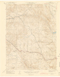
~ Ralston Buttes CO topo map, 1:31680 scale, 7.5 X 7.5 Minute, Historical, 1944
Ralston Buttes, Colorado, USGS topographic map dated 1944.
Includes geographic coordinates (latitude and longitude). This topographic map is suitable for hiking, camping, and exploring, or framing it as a wall map.
Printed on-demand using high resolution imagery, on heavy weight and acid free paper, or alternatively on a variety of synthetic materials.
Topos available on paper, Waterproof, Poly, or Tyvek. Usually shipping rolled, unless combined with other folded maps in one order.
- Product Number: USGS-5357983
- Free digital map download (high-resolution, GeoPDF): Ralston Buttes, Colorado (file size: 5 MB)
- Map Size: please refer to the dimensions of the GeoPDF map above
- Weight (paper map): ca. 55 grams
- Map Type: POD USGS Topographic Map
- Map Series: HTMC
- Map Verison: Historical
- Cell ID: 36963
- Scan ID: 402558
- Survey Year: 1942
- Datum: NAD27
- Map Projection: Polyconic
- Map published by United States Geological Survey
- Map Language: English
- Scanner Resolution: 508 dpi
- Map Cell Name: Ralston Buttes
- Grid size: 7.5 X 7.5 Minute
- Date on map: 1944
- Map Scale: 1:31680
- Geographical region: Colorado, United States
Neighboring Maps:
All neighboring USGS topo maps are available for sale online at a variety of scales.
Spatial coverage:
Topo map Ralston Buttes, Colorado, covers the geographical area associated the following places:
- B Gilman Ranch Pegmatite Mine - Mena Mine - Mount Tom - Grosso Mine - Grannys Head - S B Strang Ralston Creek Pegmatite Mine - Sawmill Gulch - Bachman Ranch Pegmatite Mine - Golden Gate Fire Protection District Station 1 - Ascension Mine - Centennial Cone - Robinson Gulch Mine - Cervi Lease Mine - Coal Creek Canyon Fire Department Station 3 - Forgotten Valley - Little Abner Pegmatite Mine - Cressmans Gulch Mine - Mount Galbraith - Centralia Mountain - Drew Hill Pegmatite Mine Number One - Guy Hill - Ladwig Number Two Mine - Golden Division - Robinson Gulch - K L Green Ranch Pegmatite Mine - Golden Gate Fire Protection District Station 2 - Nott Creek - Crawford Gulch - Johnson Number Two Mine - Shewartzwalder Mine - Elledge Beryl Prospect Mine - Hoffmeister Uranium Prospect Mine - Coors Quarry - U P Shaft Mine - Schwartzwalder Heliport - Johnson Mine - Deer Creek - Fork Prospect Mine - Centennial Ranch - Ladwig Ranch Pegmatite Mine - Ohman Mine - Ladwig-Grosso Pegmatite Mine - Belcher Hill - Ralston Buttes - Clay - Murphy Mine - Fred Pierce Ranch Mine - Halfmile Gulch - Fire Clay - Aubrey Ladwig Mine - Wilson Clay Mine - Ramstetter Ranch Mine
- Map Area ID: AREA39.87539.75-105.375-105.25
- Northwest corner Lat/Long code: USGSNW39.875-105.375
- Northeast corner Lat/Long code: USGSNE39.875-105.25
- Southwest corner Lat/Long code: USGSSW39.75-105.375
- Southeast corner Lat/Long code: USGSSE39.75-105.25
- Northern map edge Latitude: 39.875
- Southern map edge Latitude: 39.75
- Western map edge Longitude: -105.375
- Eastern map edge Longitude: -105.25


