
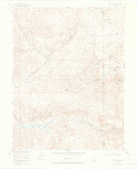
~ Windy Peak CO topo map, 1:24000 scale, 7.5 X 7.5 Minute, Historical, 1954, updated 1968
Windy Peak, Colorado, USGS topographic map dated 1954.
Includes geographic coordinates (latitude and longitude). This topographic map is suitable for hiking, camping, and exploring, or framing it as a wall map.
Printed on-demand using high resolution imagery, on heavy weight and acid free paper, or alternatively on a variety of synthetic materials.
Topos available on paper, Waterproof, Poly, or Tyvek. Usually shipping rolled, unless combined with other folded maps in one order.
- Product Number: USGS-5357707
- Free digital map download (high-resolution, GeoPDF): Windy Peak, Colorado (file size: 7 MB)
- Map Size: please refer to the dimensions of the GeoPDF map above
- Weight (paper map): ca. 55 grams
- Map Type: POD USGS Topographic Map
- Map Series: HTMC
- Map Verison: Historical
- Cell ID: 49441
- Scan ID: 401760
- Imprint Year: 1968
- Visual Version Number: 2
- Aerial Photo Year: 1950
- Field Check Year: 1954
- Datum: NAD27
- Map Projection: Polyconic
- Map published by United States Geological Survey
- Map Language: English
- Scanner Resolution: 508 dpi
- Map Cell Name: Windy Peak
- Grid size: 7.5 X 7.5 Minute
- Date on map: 1954
- Map Scale: 1:24000
- Geographical region: Colorado, United States
Neighboring Maps:
All neighboring USGS topo maps are available for sale online at a variety of scales.
Spatial coverage:
Topo map Windy Peak, Colorado, covers the geographical area associated the following places:
- Sunnyside Ranch - Aspen Lode Pegmatite Mine - Wigwam Park - Bluestem Draw - Lone and Lonesome Lodes Pegmatite Mine - East Lost Park - Rolling Creek Trail - Pine Ridge Trail - Bancroft Ranch - Soderstrom Ranch - North Rolling Creek - Sylvania of the Rockies - Upper Craig Creek Ditch - Maxwell Ditch - The Castle - Windy Peak - Craig Meadows
- Map Area ID: AREA39.37539.25-105.5-105.375
- Northwest corner Lat/Long code: USGSNW39.375-105.5
- Northeast corner Lat/Long code: USGSNE39.375-105.375
- Southwest corner Lat/Long code: USGSSW39.25-105.5
- Southeast corner Lat/Long code: USGSSE39.25-105.375
- Northern map edge Latitude: 39.375
- Southern map edge Latitude: 39.25
- Western map edge Longitude: -105.5
- Eastern map edge Longitude: -105.375


