
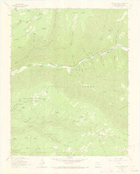
~ Wallace Ranch CO topo map, 1:24000 scale, 7.5 X 7.5 Minute, Historical, 1963, updated 1972
Wallace Ranch, Colorado, USGS topographic map dated 1963.
Includes geographic coordinates (latitude and longitude). This topographic map is suitable for hiking, camping, and exploring, or framing it as a wall map.
Printed on-demand using high resolution imagery, on heavy weight and acid free paper, or alternatively on a variety of synthetic materials.
Topos available on paper, Waterproof, Poly, or Tyvek. Usually shipping rolled, unless combined with other folded maps in one order.
- Product Number: USGS-5357367
- Free digital map download (high-resolution, GeoPDF): Wallace Ranch, Colorado (file size: 6 MB)
- Map Size: please refer to the dimensions of the GeoPDF map above
- Weight (paper map): ca. 55 grams
- Map Type: POD USGS Topographic Map
- Map Series: HTMC
- Map Verison: Historical
- Cell ID: 47317
- Scan ID: 401895
- Imprint Year: 1972
- Woodland Tint: Yes
- Aerial Photo Year: 1958
- Field Check Year: 1963
- Datum: NAD27
- Map Projection: Polyconic
- Map published by United States Geological Survey
- Map Language: English
- Scanner Resolution: 508 dpi
- Map Cell Name: Wallace Ranch
- Grid size: 7.5 X 7.5 Minute
- Date on map: 1963
- Map Scale: 1:24000
- Geographical region: Colorado, United States
Neighboring Maps:
All neighboring USGS topo maps are available for sale online at a variety of scales.
Spatial coverage:
Topo map Wallace Ranch, Colorado, covers the geographical area associated the following places:
- Quarry (historical) - Taylor Mesa Reservoir - Ellermeyer Gulch - Burnette Canyon - Morgan Reservoir - Lost Reservoir - Turkey Point Spring - Aspen Spring - Calico Spring - Twin Fir Spring - Priest Gulch Trailhead - High Reservoir - Cushman Gulch - Section House Draw - Ox Shoe Gulch - Wallace Ranch - Blue Spring - Spring Creek Reservoir - Roy Reservoir - Morrison Trail - Copinger Reservoir - Ramsay Reservoir - Upper Pole Reservoir - Greenlee Reservoir - Spring Creek Point Reservoir - Circle K Ranch - Driveway Reservoir - Bear Reservoir - Black Reservoir - Lost Canyon Stock Driveway - Dolores River Placer - Missouri Girl Mine - Lower Pole Reservoir - Priest Gulch - Siphon Spring - Bear Creek (historical) - Drift Fence Spring - Stewart Gulch - Water Tank Gulch - Walker Spring - Dipping Vat Creek - Bauer Reservoir - Mud Reservoir - Blue Spring Draw - Aspen Reservoir - Spruce Spring - Negro Draw - Middle Reservoir - Munson Gulch - Fish Creek - Pipe Creek Reservoir - Rio Lado (historical) - Low Reservoir - Little Taylor Creek - Priest Gulch Campground - Rio Lado - Fivemile Reservoir - Bear Creek - Barnard Reservoir - Little Bear Creek - Little Bear Trail
- Map Area ID: AREA37.62537.5-108.25-108.125
- Northwest corner Lat/Long code: USGSNW37.625-108.25
- Northeast corner Lat/Long code: USGSNE37.625-108.125
- Southwest corner Lat/Long code: USGSSW37.5-108.25
- Southeast corner Lat/Long code: USGSSE37.5-108.125
- Northern map edge Latitude: 37.625
- Southern map edge Latitude: 37.5
- Western map edge Longitude: -108.25
- Eastern map edge Longitude: -108.125


