
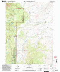
~ Teal Lake CO topo map, 1:24000 scale, 7.5 X 7.5 Minute, Historical, 2000, updated 2004
Teal Lake, Colorado, USGS topographic map dated 2000.
Includes geographic coordinates (latitude and longitude). This topographic map is suitable for hiking, camping, and exploring, or framing it as a wall map.
Printed on-demand using high resolution imagery, on heavy weight and acid free paper, or alternatively on a variety of synthetic materials.
Topos available on paper, Waterproof, Poly, or Tyvek. Usually shipping rolled, unless combined with other folded maps in one order.
- Product Number: USGS-5356637
- Free digital map download (high-resolution, GeoPDF): Teal Lake, Colorado (file size: 12 MB)
- Map Size: please refer to the dimensions of the GeoPDF map above
- Weight (paper map): ca. 55 grams
- Map Type: POD USGS Topographic Map
- Map Series: HTMC
- Map Verison: Historical
- Cell ID: 71799
- Scan ID: 234686
- Imprint Year: 2004
- Woodland Tint: Yes
- Aerial Photo Year: 1999
- Edit Year: 2000
- Datum: NAD27
- Map Projection: Lambert Conformal Conic
- Map published by United States Forest Service
- Map Language: English
- Scanner Resolution: 600 dpi
- Map Cell Name: Teal Lake
- Grid size: 7.5 X 7.5 Minute
- Date on map: 2000
- Map Scale: 1:24000
- Geographical region: Colorado, United States
Neighboring Maps:
All neighboring USGS topo maps are available for sale online at a variety of scales.
Spatial coverage:
Topo map Teal Lake, Colorado, covers the geographical area associated the following places:
- Staples Ditch Number 2 - Johnson Ranch - Newcomb Creek - Powell Ditch - Bennett and Leshner Ditch - Sawmill Creek - Ross Reservoir - Cook Ditch - Chedsey Ditch Number 2 - Newcomb Ditch - Bennett Dam - Easson Ditch - Badger Ditch - Geer Ranch - Grizzly Creek Guard Station - Burns Dam - Lucky Penny Ditch - Rock Dam - Columbine Ditch - Hidden Lakes Campground - Bennett Reservoir - Darling Ditch - Chapman Ditch - Ross Ditch Extension - Doran Ditch - Burns Reservoir - Baker Ditch - Tiago Lake - Rock Reservoir - Sawmill Lake - Whalen Creek - Staples Ditch Number 1 - Antelope Ditch - Newcomb Park - Darling Creek - Grizzly Creek Campground - Johnson Ranch - Teal Lake - Burns Ditch - Jennie Ditch - Manville Ranch - Hidden Lakes - Crosby Creek - Stambaugh Reservoir - Glendale Ditch - Stambaugh Dam - Butler School - Ross Ditch - Doran Creek - Andrew Norrell Ditch - Burns Draw
- Map Area ID: AREA40.62540.5-106.625-106.5
- Northwest corner Lat/Long code: USGSNW40.625-106.625
- Northeast corner Lat/Long code: USGSNE40.625-106.5
- Southwest corner Lat/Long code: USGSSW40.5-106.625
- Southeast corner Lat/Long code: USGSSE40.5-106.5
- Northern map edge Latitude: 40.625
- Southern map edge Latitude: 40.5
- Western map edge Longitude: -106.625
- Eastern map edge Longitude: -106.5


