
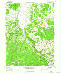
~ Suicide Mountain CO topo map, 1:24000 scale, 7.5 X 7.5 Minute, Historical, 1962, updated 1964
Suicide Mountain, Colorado, USGS topographic map dated 1962.
Includes geographic coordinates (latitude and longitude). This topographic map is suitable for hiking, camping, and exploring, or framing it as a wall map.
Printed on-demand using high resolution imagery, on heavy weight and acid free paper, or alternatively on a variety of synthetic materials.
Topos available on paper, Waterproof, Poly, or Tyvek. Usually shipping rolled, unless combined with other folded maps in one order.
- Product Number: USGS-5356513
- Free digital map download (high-resolution, GeoPDF): Suicide Mountain, Colorado (file size: 13 MB)
- Map Size: please refer to the dimensions of the GeoPDF map above
- Weight (paper map): ca. 55 grams
- Map Type: POD USGS Topographic Map
- Map Series: HTMC
- Map Verison: Historical
- Cell ID: 43662
- Scan ID: 234633
- Imprint Year: 1964
- Woodland Tint: Yes
- Aerial Photo Year: 1960
- Field Check Year: 1962
- Datum: NAD27
- Map Projection: Polyconic
- Map published by United States Geological Survey
- Map Language: English
- Scanner Resolution: 600 dpi
- Map Cell Name: Suicide Mountain
- Grid size: 7.5 X 7.5 Minute
- Date on map: 1962
- Map Scale: 1:24000
- Geographical region: Colorado, United States
Neighboring Maps:
All neighboring USGS topo maps are available for sale online at a variety of scales.
Spatial coverage:
Topo map Suicide Mountain, Colorado, covers the geographical area associated the following places:
- Timber Basin - Owl Gulch - Suicide Mountain - Hardscrabble Saddle - Slow Trail Gulch - Gould Creek - Snake Ridge - Gypsum Creek Ranch Airport - White River National Forest - McBrayer and Fenner Ditch - North Hardscrabble Mountain - Fish Pond Lake - Borah Lake - Gypsum Creek Campground - Spruce Spring - Erickson Creek - Gerard Gulch - Sundell Creek - Miller Ditch - Snake Gulch - Quaker Corral - Hardscrabble Gulch - West Fork Old Mans Gulch - Pot Hole - Swamp Drain - Daggett and Parker Ditch - East Fork Old Mans Gulch - Dewey Park - The Beaver Ponds - Fish Pond Canyon - Ferguson Ditch - McBrayer Ditch - Miller Gulch Creek - Mud Spring - Grundell Creek - Stratton Ditch - Rock Spring - Cherry Creek - Dewey Park Gulch - Dry Miller Creek - Old Mans Gulch - Dewey Park Spring - Fish Pond Gulch - Yates Gulch - Ho O R Ditch
- Map Area ID: AREA39.62539.5-107-106.875
- Northwest corner Lat/Long code: USGSNW39.625-107
- Northeast corner Lat/Long code: USGSNE39.625-106.875
- Southwest corner Lat/Long code: USGSSW39.5-107
- Southeast corner Lat/Long code: USGSSE39.5-106.875
- Northern map edge Latitude: 39.625
- Southern map edge Latitude: 39.5
- Western map edge Longitude: -107
- Eastern map edge Longitude: -106.875


