
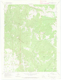
~ Porter Mountain CO topo map, 1:24000 scale, 7.5 X 7.5 Minute, Historical, 1961, updated 1972
Porter Mountain, Colorado, USGS topographic map dated 1961.
Includes geographic coordinates (latitude and longitude). This topographic map is suitable for hiking, camping, and exploring, or framing it as a wall map.
Printed on-demand using high resolution imagery, on heavy weight and acid free paper, or alternatively on a variety of synthetic materials.
Topos available on paper, Waterproof, Poly, or Tyvek. Usually shipping rolled, unless combined with other folded maps in one order.
- Product Number: USGS-5354903
- Free digital map download (high-resolution, GeoPDF): Porter Mountain, Colorado (file size: 6 MB)
- Map Size: please refer to the dimensions of the GeoPDF map above
- Weight (paper map): ca. 55 grams
- Map Type: POD USGS Topographic Map
- Map Series: HTMC
- Map Verison: Historical
- Cell ID: 36094
- Scan ID: 401381
- Imprint Year: 1972
- Woodland Tint: Yes
- Aerial Photo Year: 1956
- Field Check Year: 1961
- Datum: NAD27
- Map Projection: Polyconic
- Map published by United States Geological Survey
- Map Language: English
- Scanner Resolution: 508 dpi
- Map Cell Name: Porter Mountain
- Grid size: 7.5 X 7.5 Minute
- Date on map: 1961
- Map Scale: 1:24000
- Geographical region: Colorado, United States
Neighboring Maps:
All neighboring USGS topo maps are available for sale online at a variety of scales.
Spatial coverage:
Topo map Porter Mountain, Colorado, covers the geographical area associated the following places:
- Deep Creek Mine - Porter Creek - Carnahan Ditch Number 1 - West Porter Creek - Plateau Ridge - Porter Mountain - Bronco Knob - Castle Creek - Plateau Park - Grass Park - Owens Creek Corral - Walt Creek - Baldridge Point - Elizabethe Ditch - McKelvie Reservoir - Bull Elk Ditch - East Porter Creek - Stillwater Park - Willow Ridge - Bear Den Ditch - Elk Lake - Steep Creek - Two Peak - Buzzard Park - Wagon Park - Gander Pond - Lowell Flat - Hanson Draw - Silver Spruce Trail - The Flat Tops - Lenna Peak - Dead Mare Park - Porter Flat - Stubb Creek - Owens Creek - High Trail - Castle Ditch
- Map Area ID: AREA39.2539.125-107.75-107.625
- Northwest corner Lat/Long code: USGSNW39.25-107.75
- Northeast corner Lat/Long code: USGSNE39.25-107.625
- Southwest corner Lat/Long code: USGSSW39.125-107.75
- Southeast corner Lat/Long code: USGSSE39.125-107.625
- Northern map edge Latitude: 39.25
- Southern map edge Latitude: 39.125
- Western map edge Longitude: -107.75
- Eastern map edge Longitude: -107.625


