
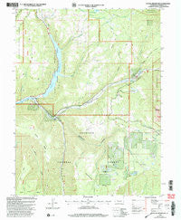
~ Paonia Reservoir CO topo map, 1:24000 scale, 7.5 X 7.5 Minute, Historical, 2001, updated 2004
Paonia Reservoir, Colorado, USGS topographic map dated 2001.
Includes geographic coordinates (latitude and longitude). This topographic map is suitable for hiking, camping, and exploring, or framing it as a wall map.
Printed on-demand using high resolution imagery, on heavy weight and acid free paper, or alternatively on a variety of synthetic materials.
Topos available on paper, Waterproof, Poly, or Tyvek. Usually shipping rolled, unless combined with other folded maps in one order.
- Product Number: USGS-5354401
- Free digital map download (high-resolution, GeoPDF): Paonia Reservoir, Colorado (file size: 14 MB)
- Map Size: please refer to the dimensions of the GeoPDF map above
- Weight (paper map): ca. 55 grams
- Map Type: POD USGS Topographic Map
- Map Series: HTMC
- Map Verison: Historical
- Cell ID: 34131
- Scan ID: 234054
- Imprint Year: 2004
- Woodland Tint: Yes
- Aerial Photo Year: 1999
- Datum: NAD27
- Map Projection: Lambert Conformal Conic
- Map published by United States Geological Survey
- Map published by United States Forest Service
- Map Language: English
- Scanner Resolution: 600 dpi
- Map Cell Name: Paonia Reservoir
- Grid size: 7.5 X 7.5 Minute
- Date on map: 2001
- Map Scale: 1:24000
- Geographical region: Colorado, United States
Neighboring Maps:
All neighboring USGS topo maps are available for sale online at a variety of scales.
Spatial coverage:
Topo map Paonia Reservoir, Colorado, covers the geographical area associated the following places:
- Snowshoe Cow Camp - Grouse Spring Creek - Anthracite Creek Guard Station - Twin Forks Ditch - The Pines - Dugout Creek - West Muddy Creek - Erickson Springs - Norris Ditch - Anthracite Creek - Williams Creek - Watson Flats - East Muddy Creek - Munsey Creek - South Snowshoe Creek - Muddy Fork - Layton Gulch - Deep Creek - Paonia Reservoir - Schaefer Creek - Ragged Mountain Fire Protection District - Williams Creek Lake - Dark Canyon - Paonia Dam - Elkhorn Stomp Ditch - Raven Mesa - Erickson Springs - Snowshoe Cabin - Muddy Creek - Snowshoe Creek - Paonia Reservoir State Recreation Area - Coyote Gulch - Hotchkiss Ranch - Dry Fork Snowshoe Creek - Fillmore Ditch - Coal Creek - Snowshoe Canyon - Vogel Creek - Somerset Division - Goose Hill - Cottonwood Creek
- Map Area ID: AREA3938.875-107.375-107.25
- Northwest corner Lat/Long code: USGSNW39-107.375
- Northeast corner Lat/Long code: USGSNE39-107.25
- Southwest corner Lat/Long code: USGSSW38.875-107.375
- Southeast corner Lat/Long code: USGSSE38.875-107.25
- Northern map edge Latitude: 39
- Southern map edge Latitude: 38.875
- Western map edge Longitude: -107.375
- Eastern map edge Longitude: -107.25


