
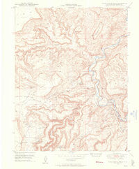
~ Horse Range Mesa CO topo map, 1:24000 scale, 7.5 X 7.5 Minute, Historical, 1948, updated 1955
Horse Range Mesa, Colorado, USGS topographic map dated 1948.
Includes geographic coordinates (latitude and longitude). This topographic map is suitable for hiking, camping, and exploring, or framing it as a wall map.
Printed on-demand using high resolution imagery, on heavy weight and acid free paper, or alternatively on a variety of synthetic materials.
Topos available on paper, Waterproof, Poly, or Tyvek. Usually shipping rolled, unless combined with other folded maps in one order.
- Product Number: USGS-5351201
- Free digital map download (high-resolution, GeoPDF): Horse Range Mesa, Colorado (file size: 9 MB)
- Map Size: please refer to the dimensions of the GeoPDF map above
- Weight (paper map): ca. 55 grams
- Map Type: POD USGS Topographic Map
- Map Series: HTMC
- Map Verison: Historical
- Cell ID: 21091
- Scan ID: 450797
- Imprint Year: 1955
- Aerial Photo Year: 1947
- Field Check Year: 1948
- Datum: NAD27
- Map Projection: Polyconic
- Map published by United States Geological Survey
- Map Language: English
- Scanner Resolution: 508 dpi
- Map Cell Name: Horse Range Mesa
- Grid size: 7.5 X 7.5 Minute
- Date on map: 1948
- Map Scale: 1:24000
- Geographical region: Colorado, United States
Neighboring Maps:
All neighboring USGS topo maps are available for sale online at a variety of scales.
Spatial coverage:
Topo map Horse Range Mesa, Colorado, covers the geographical area associated the following places:
- Tail Hold Mine - Radium Number Thirty Mine - India Mine - Skidmore Mine - Radium Number Twenty-seven Mine - Middle Group Mines - Radium Number Fifteen Mine - Slick Rock - Burro Number Seven Mine - Bottom Canyon Mine - Last Chance Mine - Prospectors Fortune Mine - Cougar Canyon - Tommy White Mine - Radium Group Mines - Lucky B Mine - Little Mariel Mine - Grants Claim Mine - Little Marie Mine - Ellison Mine - Horse Range Mesa - Michael Bray Mine - Letty Jones Mine - Slick Rock Bridge - Lower Section Mine - Burro Number Five Mine - Jackie Walls Mine - Northern Light Mine - Katydid Mine - Alice Number Four Mine - Summit Group Mine - Summit Canyon - Hanks Pocket - Mortgage Lifter Mine - Roger Number Two Mine - Penju 25 Mine - Veta Mad Mine - Mc Intyre Canyon - Radium Number Two Mine - Lower Group Mines - Grass Flat Mine - Georgetown Mine - Firefly Mine - Roger Number Five Mine - Cone Number Six Mine - Charles T Mines - Robbins Mine - Yellowbird Mine - Herbert Mine - Veta Glad Mine - Burro Tunnel Mine - Haymaker-Sunset Mine - Hawkeye Mine - Stevens Canyon - Big S Mine - A H Canfield Mine - Charlotte Number One Mine - Radium Number Thirteen Mine - Colorado Cat Mine - Summit Fraction Mine - Grassy Hills - North Slope Two Mine - Otera Incline Mine - Lucky One Mine - Deluxe Mine - Bean Mine - Corral Draw - Cougar Mine - Burro Mine - Dragon Claims Mine - Poverty Flat - Sesmo Mine - Slick Rock Hill - Sunnyside Mine - Bell Number One Mine - Lee C Mine - Sears Number One Mine - Lone Star Group Mine - Painted Rock Mine - Tailholt Mines - Pinto Mine - Golden Rod One Mine - Sundown Mine - Cape Horn - Black Fox Mine - Veta Mad Number Two Mine - Steamboat Hill - Radium Number Eleven Mine - Burro Number Three Mine - Midnight Mine - Radium Number Nine Mine - Bush Canyon Mine - East Summit - Grubstake Mine - San Miguel Mine - Uintah Adit Mine - Martha Sue Mine - Middle Yolande Mine - Jackie L Mine - Brighton Mine
- Map Area ID: AREA38.12538-109-108.875
- Northwest corner Lat/Long code: USGSNW38.125-109
- Northeast corner Lat/Long code: USGSNE38.125-108.875
- Southwest corner Lat/Long code: USGSSW38-109
- Southeast corner Lat/Long code: USGSSE38-108.875
- Northern map edge Latitude: 38.125
- Southern map edge Latitude: 38
- Western map edge Longitude: -109
- Eastern map edge Longitude: -108.875


