
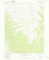
~ Battle Mountain CO topo map, 1:24000 scale, 7.5 X 7.5 Minute, Historical, 1979, updated 1979
Battle Mountain, Colorado, USGS topographic map dated 1979.
Includes geographic coordinates (latitude and longitude). This topographic map is suitable for hiking, camping, and exploring, or framing it as a wall map.
Printed on-demand using high resolution imagery, on heavy weight and acid free paper, or alternatively on a variety of synthetic materials.
Topos available on paper, Waterproof, Poly, or Tyvek. Usually shipping rolled, unless combined with other folded maps in one order.
- Product Number: USGS-5346653
- Free digital map download (high-resolution, GeoPDF): Battle Mountain, Colorado (file size: 6 MB)
- Map Size: please refer to the dimensions of the GeoPDF map above
- Weight (paper map): ca. 55 grams
- Map Type: POD USGS Topographic Map
- Map Series: HTMC
- Map Verison: Historical
- Cell ID: 2660
- Scan ID: 400329
- Imprint Year: 1979
- Woodland Tint: Yes
- Aerial Photo Year: 1975
- Edit Year: 1979
- Field Check Year: 1976
- Datum: NAD27
- Map Projection: Lambert Conformal Conic
- Map published by United States Geological Survey
- Map Language: English
- Scanner Resolution: 508 dpi
- Map Cell Name: Battle Mountain
- Grid size: 7.5 X 7.5 Minute
- Date on map: 1979
- Map Scale: 1:24000
- Geographical region: Colorado, United States
Neighboring Maps:
All neighboring USGS topo maps are available for sale online at a variety of scales.
Spatial coverage:
Topo map Battle Mountain, Colorado, covers the geographical area associated the following places:
- Lost Creek - Bull Run - Brinker Gulch - Williams Peak Trail - Langholen Reservoir - Dale Ditch - Willow View School - Skylark Creek - South Battle Creek - Langholen Dam - Dale Dam - Rohan Ditch - Curtis Ridge - Columbine School - North Skylark Ditch - Cole Reservoir - Mule Creek - Dale Reservoir - Battle Mountain - Williams Peak - Cow Creek - Cole Dam - South Fork Mule Creek - North Battle Creek
- Map Area ID: AREA4039.875-106.25-106.125
- Northwest corner Lat/Long code: USGSNW40-106.25
- Northeast corner Lat/Long code: USGSNE40-106.125
- Southwest corner Lat/Long code: USGSSW39.875-106.25
- Southeast corner Lat/Long code: USGSSE39.875-106.125
- Northern map edge Latitude: 40
- Southern map edge Latitude: 39.875
- Western map edge Longitude: -106.25
- Eastern map edge Longitude: -106.125


