
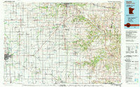
~ Austin MN topo map, 1:100000 scale, 30 X 60 Minute, Historical, 1985, updated 1989
Austin, Minnesota, USGS topographic map dated 1985.
Includes geographic coordinates (latitude and longitude). This topographic map is suitable for hiking, camping, and exploring, or framing it as a wall map.
Printed on-demand using high resolution imagery, on heavy weight and acid free paper, or alternatively on a variety of synthetic materials.
Topos available on paper, Waterproof, Poly, or Tyvek. Usually shipping rolled, unless combined with other folded maps in one order.
- Product Number: USGS-5345538
- Free digital map download (high-resolution, GeoPDF): Austin, Minnesota (file size: 21 MB)
- Map Size: please refer to the dimensions of the GeoPDF map above
- Weight (paper map): ca. 55 grams
- Map Type: POD USGS Topographic Map
- Map Series: HTMC
- Map Verison: Historical
- Cell ID: 67082
- Scan ID: 805569
- Imprint Year: 1989
- Woodland Tint: Yes
- Aerial Photo Year: 1982
- Edit Year: 1985
- Datum: NAD27
- Map Projection: Universal Transverse Mercator
- Map published by United States Geological Survey
- Map Language: English
- Scanner Resolution: 508 dpi
- Map Cell Name: Austin
- Grid size: 30 X 60 Minute
- Date on map: 1985
- Map Scale: 1:100000
- Geographical region: Minnesota, United States
Neighboring Maps:
All neighboring USGS topo maps are available for sale online at a variety of scales.
Spatial coverage:
Topo map Austin, Minnesota, covers the geographical area associated the following places:
- Granger - Le Roy - Brownsdale - Freiheit Spring - Bucksnort - Saint Charles - Saratoga - Westfield Center (historical) - Greenleafton - Adams - Andyville - Sargeant - Rock Dell - Hayfield - Marion - Dexter - Countryside Mobile Home Park - Le Roy Parkside Mobile Home Park - Dover - Hutton - Willow Ridge Mobile Home Park - Waltham - Fountain - Paradise Trailer Court - Forestville - Bobs Trailer Court - Cummingsville - Mayville - Spring Valley - Austin - York - High Forest - Rose Creek - Ostrander Mobile Home Park - Golden Hill - Stewartville - Simpson - Carimona - Predmore - Mapleview - Racine - Varco - Elkton - Pleasant Grove - Eyota - Washington - Wykoff Mobile Home Park II - Troy - Wykoff - Ramsey - Salem Corners - Preston - Harmony - Spring Valley Trailer Park - Chatfield - Cherry Grove - Southern Hills Mobile Home Park - Vernon - Parkside Mobile Home Park - Vista Village Mobile Home Park - Shanty Town - Vlasaty - Wykoff Mobile Home Park I - Meadow Mobile Home Park - Hamilton - Nicolville - Vikre Manufactured Home Park - Big Spring - Austin Mobile Home Park - Pleasant Acres Mobile Home Park - Ransom Trailer Court - Lansing - Judge - Poolers Mobile Home Park - Taopi - Shady Acre Mobile Home Park - New Horizons Mobile Home Park - Isinours - Harmony Mobile Home Park - Renova - Ostrander - Fillmore - Pleasant Valley Mobile Home Park - Lyle - Johnsburg - Oslo - Preston Mobile Home Park - Southside Mobile Home Park - Bristol - Etna - Grand Meadow
- Map Area ID: AREA4443.5-93-92
- Northwest corner Lat/Long code: USGSNW44-93
- Northeast corner Lat/Long code: USGSNE44-92
- Southwest corner Lat/Long code: USGSSW43.5-93
- Southeast corner Lat/Long code: USGSSE43.5-92
- Northern map edge Latitude: 44
- Southern map edge Latitude: 43.5
- Western map edge Longitude: -93
- Eastern map edge Longitude: -92


