
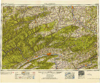
~ Williamsport PA topo map, 1:250000 scale, 1 X 2 Degree, Historical, 1954, updated 1954
Williamsport, Pennsylvania, USGS topographic map dated 1954.
Includes geographic coordinates (latitude and longitude). This topographic map is suitable for hiking, camping, and exploring, or framing it as a wall map.
Printed on-demand using high resolution imagery, on heavy weight and acid free paper, or alternatively on a variety of synthetic materials.
Topos available on paper, Waterproof, Poly, or Tyvek. Usually shipping rolled, unless combined with other folded maps in one order.
- Product Number: USGS-5332084
- Free digital map download (high-resolution, GeoPDF): Williamsport, Pennsylvania (file size: 19 MB)
- Map Size: please refer to the dimensions of the GeoPDF map above
- Weight (paper map): ca. 55 grams
- Map Type: POD USGS Topographic Map
- Map Series: HTMC
- Map Verison: Historical
- Cell ID: 69099
- Scan ID: 222576
- Imprint Year: 1954
- Woodland Tint: Yes
- Aerial Photo Year: 1939
- Datum: NAD27
- Map Projection: Transverse Mercator
- Map published by United States Army Corps of Engineers
- Map published by United States Army
- Map Language: English
- Scanner Resolution: 600 dpi
- Map Cell Name: Williamsport
- Grid size: 1 X 2 Degree
- Date on map: 1954
- Map Scale: 1:250000
- Geographical region: Pennsylvania, United States
Neighboring Maps:
All neighboring USGS topo maps are available for sale online at a variety of scales.
Spatial coverage:
Topo map Williamsport, Pennsylvania, covers the geographical area associated the following places:
- Dieffenbach - Huntington Mills - Saco - Windfall - Cooks Run - Beech Creek - Scanlin - Delaware Run - Wells Hollow - House Landing Strip - Wilmot - Rush - Calvert - Leetonia - Eleven Mile - Lee - Galeton - Logue - Hammersley - Mosherville - Black - Willow Springs - Hickox - Friendsville - Lehman - Clarence - Balls Mills - Balsam - Alden - North Orwell - Kellyburg - Bloomingdale - Stull - East Canton - Hartsfield - Little Meadows - Manhattan - Nescopeck - Frinks - Sheshequin - Foundryville - Little Marsh - Rushville - Raymond - Nisbet - Villa Grove - Proctor - Waterville - Gold - Azelta - Roseville - Christian Hill - West Covington - Antrim - Liberty - Loyalsock (historical) - Five Points - Maple Grove - Evansville - Stillwater - East Point - Owl Hollow - Ringdale - Shickshinny - Briar Creek - Ripple - Kyttle - Stokesdale - Knoxville - Newberry - Rising - Purple Brook (historical) - South Hill - Daggett - Koonsville - Millview - Logan Mills - Tyrrell - West Leroy - Eyers Grove - Harkness - Glen Mawr - Plank - Canyon Vista - Lebo Vista - Hunlock - Stairville - Howard - West Burlington - Unityville - Gillintown - Monument - Huffs Corner - East Millville - Lockport - Twin Hollows - Bluestone - Kinney - Shettleston - California
- Map Area ID: AREA4241-78-76
- Northwest corner Lat/Long code: USGSNW42-78
- Northeast corner Lat/Long code: USGSNE42-76
- Southwest corner Lat/Long code: USGSSW41-78
- Southeast corner Lat/Long code: USGSSE41-76
- Northern map edge Latitude: 42
- Southern map edge Latitude: 41
- Western map edge Longitude: -78
- Eastern map edge Longitude: -76


