
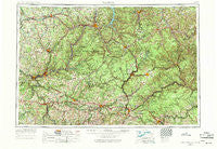
~ Warren PA topo map, 1:250000 scale, 1 X 2 Degree, Historical, 1957, updated 1971
Warren, Pennsylvania, USGS topographic map dated 1957.
Includes geographic coordinates (latitude and longitude). This topographic map is suitable for hiking, camping, and exploring, or framing it as a wall map.
Printed on-demand using high resolution imagery, on heavy weight and acid free paper, or alternatively on a variety of synthetic materials.
Topos available on paper, Waterproof, Poly, or Tyvek. Usually shipping rolled, unless combined with other folded maps in one order.
- Product Number: USGS-5332072
- Free digital map download (high-resolution, GeoPDF): Warren, Pennsylvania (file size: 21 MB)
- Map Size: please refer to the dimensions of the GeoPDF map above
- Weight (paper map): ca. 55 grams
- Map Type: POD USGS Topographic Map
- Map Series: HTMC
- Map Verison: Historical
- Cell ID: 69086
- Scan ID: 222386
- Imprint Year: 1971
- Woodland Tint: Yes
- Photo Revision Year: 1969
- Aerial Photo Year: 1956
- Field Check Year: 1957
- Datum: Unstated
- Map Projection: Transverse Mercator
- Map published by: Military, Other
- Map Language: English
- Scanner Resolution: 600 dpi
- Map Cell Name: Warren
- Grid size: 1 X 2 Degree
- Date on map: 1957
- Map Scale: 1:250000
- Geographical region: Pennsylvania, United States
Neighboring Maps:
All neighboring USGS topo maps are available for sale online at a variety of scales.
Spatial coverage:
Topo map Warren, Pennsylvania, covers the geographical area associated the following places:
- East Smethport - Gaffney - Freeman - Toby - Five Points - Pancoast - Mount Pleasant - McKean - Dutch Hill - Summit - Black Ash - Wentlings Corners - Marshburg - Atwells Crossing - Gardeau - Neilltown - Clara - Nansen - Enterprise - Jackson Run - Five Points - Hallton - Heathville - Port Allegany - Crates - Brandon - Tillotson - Corsica - Kiser Corners - Roseville - Kahletown - Conifer - Oak Hill - Egypt - Wishaw - Clapp Lease - South Sulger (historical) - Baxter - Glen Hazel - Bald Hill - Glendale (historical) - Squab Hollow - East Wayne - Sheffield - Takitezy - Bear Lake - Weldbank - Stump Creek - Guitonville - Wilcox - Sandy Point - Roystone - Kingsville - Kohlmeyer Corner - Ceres - Walkertown - Gilmore - Kibbeville - Belford - Soldier - Tait - Church Hill - Elk City - Nebraska - Rockdale - Sandy - Moniteau - Kersey - Colonial Village - Rolling Stone - Foster Corner - Surveyor - Old Sheffield - Coal Hill - Guys Mills - Cortez - Streights - Greendale - Wheelock - Kaulmont - Nicklin - Prentisvale - Brown Hill - Yellow Hammer - Barnes - Newmansville - Queen - Twomile - Donaldson - Boyers - Corwins Corners - Coryville - Pioneer - Whiskerville - Five Points - Monroe - Scotch Hill - Indian Head - Drifting - Ridgway
- Map Area ID: AREA4241-80-78
- Northwest corner Lat/Long code: USGSNW42-80
- Northeast corner Lat/Long code: USGSNE42-78
- Southwest corner Lat/Long code: USGSSW41-80
- Southeast corner Lat/Long code: USGSSE41-78
- Northern map edge Latitude: 42
- Southern map edge Latitude: 41
- Western map edge Longitude: -80
- Eastern map edge Longitude: -78


