
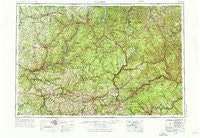
~ Warren PA topo map, 1:250000 scale, 1 X 2 Degree, Historical, 1957, updated 1976
Warren, Pennsylvania, USGS topographic map dated 1957.
Includes geographic coordinates (latitude and longitude). This topographic map is suitable for hiking, camping, and exploring, or framing it as a wall map.
Printed on-demand using high resolution imagery, on heavy weight and acid free paper, or alternatively on a variety of synthetic materials.
Topos available on paper, Waterproof, Poly, or Tyvek. Usually shipping rolled, unless combined with other folded maps in one order.
- Product Number: USGS-5332070
- Free digital map download (high-resolution, GeoPDF): Warren, Pennsylvania (file size: 21 MB)
- Map Size: please refer to the dimensions of the GeoPDF map above
- Weight (paper map): ca. 55 grams
- Map Type: POD USGS Topographic Map
- Map Series: HTMC
- Map Verison: Historical
- Cell ID: 69086
- Scan ID: 222385
- Imprint Year: 1976
- Woodland Tint: Yes
- Visual Version Number: 1
- Photo Revision Year: 1969
- Aerial Photo Year: 1956
- Field Check Year: 1957
- Datum: Unstated
- Map Projection: Transverse Mercator
- Map published by: Military, Other
- Map Language: English
- Scanner Resolution: 600 dpi
- Map Cell Name: Warren
- Grid size: 1 X 2 Degree
- Date on map: 1957
- Map Scale: 1:250000
- Geographical region: Pennsylvania, United States
Neighboring Maps:
All neighboring USGS topo maps are available for sale online at a variety of scales.
Spatial coverage:
Topo map Warren, Pennsylvania, covers the geographical area associated the following places:
- Wolfs Corners - Strobleton - Pithole City - Berge Run - Guffey - Waterford - Snydersburg - Putnamville - Rouseville - Mina - Content - Blue Jay - Victory Heights - Astral - Minister - Streights - Loleta - Stone House - Dallas City - Saybrook - Harlan - Clappville - Clarion - Stoneham - Falls Creek - Mount Jewett - Venturetown - McKinley - Luthersburg - Prentisvale - Gaffney - Hollywood - Sharon Center - Richardsville - Petroleum Center - Lecontes Mills - Claytonia - Woodland Heights - Mapledale - Smithland - Medix Run - Marvindale - Pleasant Hill - Bishtown - Desire - Hillville - Plum Corner - Pineville - Kerr Addition - Dahoga - Coal Glen - Eldred Center - Humphreys Corner - Norman - Curllsville - O'Donnell - Five Points - Helen Mills - Custer City - Gilfoyle - Cooksburg - Narrows Creek - Mount Joy - Sutton Mill - Haslets Corner - Queenstown - Threemile - Degolia - Truittsburg - Gravel Lick - Allen - Honeoye - Grand Valley - Reno - Bald Hill - Wentlings Corners - Reidsburg - Starr - Huefner - East Wayne - Guitonville - Garland - Campbelltown - Black Ash - Fairmont City - Williamsburg - Rockdale - Stump Creek - Sheffield - Shinglehouse - Crosby - Scandia - Russell - Turtlepoint - Limestone - Wolf Run - Smithtown - Red Rock - Rew - Weber City
- Map Area ID: AREA4241-80-78
- Northwest corner Lat/Long code: USGSNW42-80
- Northeast corner Lat/Long code: USGSNE42-78
- Southwest corner Lat/Long code: USGSSW41-80
- Southeast corner Lat/Long code: USGSSE41-78
- Northern map edge Latitude: 42
- Southern map edge Latitude: 41
- Western map edge Longitude: -80
- Eastern map edge Longitude: -78


