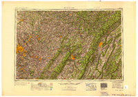
~ Pittsburgh PA topo map, 1:250000 scale, 1 X 2 Degree, Historical, 1953, updated 1953
Pittsburgh, Pennsylvania, USGS topographic map dated 1953.
Includes geographic coordinates (latitude and longitude). This topographic map is suitable for hiking, camping, and exploring, or framing it as a wall map.
Printed on-demand using high resolution imagery, on heavy weight and acid free paper, or alternatively on a variety of synthetic materials.
Topos available on paper, Waterproof, Poly, or Tyvek. Usually shipping rolled, unless combined with other folded maps in one order.
- Product Number: USGS-5332056
- Free digital map download (high-resolution, GeoPDF): Pittsburgh, Pennsylvania (file size: 16 MB)
- Map Size: please refer to the dimensions of the GeoPDF map above
- Weight (paper map): ca. 55 grams
- Map Type: POD USGS Topographic Map
- Map Series: HTMC
- Map Verison: Historical
- Cell ID: 68961
- Scan ID: 707521
- Imprint Year: 1953
- Woodland Tint: Yes
- Aerial Photo Year: 1941
- Datum: NAD27
- Map Projection: Transverse Mercator
- Shaded Relief map: Yes
- Map published by United States Army Corps of Engineers
- Map published by United States Army
- Map Language: English
- Scanner Resolution: 508 dpi
- Map Cell Name: Pittsburgh
- Grid size: 1 X 2 Degree
- Date on map: 1953
- Map Scale: 1:250000
- Geographical region: Pennsylvania, United States
Neighboring Maps:
All neighboring USGS topo maps are available for sale online at a variety of scales.
Spatial coverage:
Topo map Pittsburgh, Pennsylvania, covers the geographical area associated the following places:
- Chickaree - Klahr - Allport - Vinco - Lincoln-Lemington - Queen Junction - McIntyre - Brisbin - North Versailles - Highland - Regency Park - Yellow Creek - West Lebanon - East Oakmont - Ostend - Roxbury - Lernerville - Reesedale - Beyer - Churchill Valley - McBride - Gahagen - Hale - Twilight - Garden City - Centennial - Philipsburg - Puzzletown - McVille - Driscoll - Brentwood - Hunker - Plattsville - Smithville - Truxall - Jefferson Center - Eldorado - Seamentown - Texas Corner - Wells - Export - Longbridge - Morgans Land - Jamisonville - Saint Charles - Hileman Heights - Laurel Summit - Fowler Heights - Luxor - Tyrone - Ernest - Gibsonia - Duquesne - Dicksonville - Acmetonia - Pemberton - Sonman - Everson - Muddy Creek - Lynnwood - Spring Garden - Waltzvale - Stifflertown - Oshanter - Ginger Hill - Orchard Hill - Coupon - Surgeon Hall - Greenwood - Adams - Pattonville - Ewing - Alta Manor - Prospect - Spindley City - Buena Vista - Standard - Calvert Hills - Indian Head - McCullough - Grand View - Monroe Heights - Snydertown - Wesley Chapel - Dock Hollow - Dublin Mills - New Derry - Radebaugh - Waterford - Brushton - Penn Glyn - Robindale Heights - Coffman - Stewart - Leamersville - Grafton - West Decatur - Morrows Corner - Renfrew - Rimer
- Map Area ID: AREA4140-80-78
- Northwest corner Lat/Long code: USGSNW41-80
- Northeast corner Lat/Long code: USGSNE41-78
- Southwest corner Lat/Long code: USGSSW40-80
- Southeast corner Lat/Long code: USGSSE40-78
- Northern map edge Latitude: 41
- Southern map edge Latitude: 40
- Western map edge Longitude: -80
- Eastern map edge Longitude: -78

