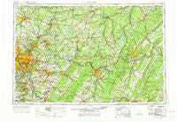
~ Pittsburgh PA topo map, 1:250000 scale, 1 X 2 Degree, Historical, 1958, updated 1975
Pittsburgh, Pennsylvania, USGS topographic map dated 1958.
Includes geographic coordinates (latitude and longitude). This topographic map is suitable for hiking, camping, and exploring, or framing it as a wall map.
Printed on-demand using high resolution imagery, on heavy weight and acid free paper, or alternatively on a variety of synthetic materials.
Topos available on paper, Waterproof, Poly, or Tyvek. Usually shipping rolled, unless combined with other folded maps in one order.
- Product Number: USGS-5332050
- Free digital map download (high-resolution, GeoPDF): Pittsburgh, Pennsylvania (file size: 20 MB)
- Map Size: please refer to the dimensions of the GeoPDF map above
- Weight (paper map): ca. 55 grams
- Map Type: POD USGS Topographic Map
- Map Series: HTMC
- Map Verison: Historical
- Cell ID: 68961
- Scan ID: 221429
- Imprint Year: 1975
- Woodland Tint: Yes
- Visual Version Number: 2
- Aerial Photo Year: 1958
- Edit Year: 1969
- Datum: Unstated
- Map Projection: Transverse Mercator
- Map published by: Military, Other
- Map Language: English
- Scanner Resolution: 600 dpi
- Map Cell Name: Pittsburgh
- Grid size: 1 X 2 Degree
- Date on map: 1958
- Map Scale: 1:250000
- Geographical region: Pennsylvania, United States
Neighboring Maps:
All neighboring USGS topo maps are available for sale online at a variety of scales.
Spatial coverage:
Topo map Pittsburgh, Pennsylvania, covers the geographical area associated the following places:
- Penn Ridge - Brumbaugh - Sagamore - Flinton - Tanoma - Tarentum - Talley Cavey - North Buffalo - Sonman - Logan - Oakmont - Tarrs - Hites - Laketon Heights - Marron - Mellingertown - Broad Ford - Northvue - Sandy Ridge - Edna Number Two - Maysville - Belmar - Bear Loop - Georges Station - Gazzam - Richland - Saxonburg - Red Mill - Long Run - Stonevilla - Van Meter - Curryville - Mount Pleasant - Sharrertown - Brisbin - Muddy Creek - Munhall - Tatesville - West Homestead - Chevy Chase Heights - North Manor - Cotton Town - Whiteside - Ligonier - Loyalhanna Woodlands Number 2 - Woodbury - Top - Foster - Beavertown - White - Dorseyville - Reduction - Stahlstown - Drennen - Lockport - Evanstown - Wesley Chapel - McKeages Crossing - Allendale - Woodglen - Marchand - Highfield - Jenners - East Elizabeth - Eichelbergertown - Weimer - Shazen - Claypoole Heights - Edie - Blackburn - Rural Ridge - Jefferson Hills - Polish Hill - Unionville - Porter - Crete - Collinsburg - East Brady - Aspinwall - Pleasant Grove - Wilpen - Boggsville - Orners Corner - Marshall Heights - Coy Junction - North Philipsburg - Pleasant Hills - Smithdale - Rochester Mills - Napier - Elben - Putneyville - Gracey - Barnards - New Castle - Renfrew - Plattsville - Acmetonia - Kimmel - Foxton
- Map Area ID: AREA4140-80-78
- Northwest corner Lat/Long code: USGSNW41-80
- Northeast corner Lat/Long code: USGSNE41-78
- Southwest corner Lat/Long code: USGSSW40-80
- Southeast corner Lat/Long code: USGSSE40-78
- Northern map edge Latitude: 41
- Southern map edge Latitude: 40
- Western map edge Longitude: -80
- Eastern map edge Longitude: -78

