
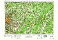
~ Pittsburgh PA topo map, 1:250000 scale, 1 X 2 Degree, Historical, 1958, updated 1966
Pittsburgh, Pennsylvania, USGS topographic map dated 1958.
Includes geographic coordinates (latitude and longitude). This topographic map is suitable for hiking, camping, and exploring, or framing it as a wall map.
Printed on-demand using high resolution imagery, on heavy weight and acid free paper, or alternatively on a variety of synthetic materials.
Topos available on paper, Waterproof, Poly, or Tyvek. Usually shipping rolled, unless combined with other folded maps in one order.
- Product Number: USGS-5332048
- Free digital map download (high-resolution, GeoPDF): Pittsburgh, Pennsylvania (file size: 20 MB)
- Map Size: please refer to the dimensions of the GeoPDF map above
- Weight (paper map): ca. 55 grams
- Map Type: POD USGS Topographic Map
- Map Series: HTMC
- Map Verison: Historical
- Cell ID: 68961
- Scan ID: 221428
- Imprint Year: 1966
- Woodland Tint: Yes
- Edit Year: 1965
- Datum: Unstated
- Map Projection: Transverse Mercator
- Map published by United States Army Corps of Engineers
- Map published by United States Army
- Map Language: English
- Scanner Resolution: 600 dpi
- Map Cell Name: Pittsburgh
- Grid size: 1 X 2 Degree
- Date on map: 1958
- Map Scale: 1:250000
- Geographical region: Pennsylvania, United States
Neighboring Maps:
All neighboring USGS topo maps are available for sale online at a variety of scales.
Spatial coverage:
Topo map Pittsburgh, Pennsylvania, covers the geographical area associated the following places:
- Stiles Crossing - Braznell - Heilman - Bairdstown - Highland - Herman - Dry Hill - Denbeau Heights - Mahoning Furnace - Garmantown - Grindstone - Truxall - Greenville - Muddy Creek - Coy - Blairfour - Glen Hazel - Millersdale - Wandin Junction - Bridgeburg - Morrows Corner - Upper Reese - Cochrans Mill - Pleasant Hill - Schenley - Charlottsville - New Millport - Lorain - Moyer - Ford City - Wehnwood - Five Points - Buckeye - Winslow - Penn Ridge - Somerville - Grandview - Hostetter - Colfax - Apollo - Trafford - Smathers - Newtown - Shawtown - Fairmount - New Eagle - Sterling - United - Blanchard - Mount Oliver - Tatesville - Boltz - Pleasant Valley - Preisser Crossing - Southside Slopes - Palmers - Penn Hills - Boone - Beavertown - Centerville - West Newton - Starford - Pine Hill - Elstie - Reillys - Kintersburg - Van Dykes - Point View - Millvale - Coral - Greenwich - Dravosburg - Nihil - Kimmel - Gatesburg - Powelton - Hilldale - Cunningham - Laurelville - McVille - Culmerville - Jimtown - McChesneytown - Silverville - Tunnelville (historical) - Tearing Run - Ostend - Denton - Helixville - Gibsonton - Courtney - Wallace - New Salem - West Decatur - Seanor - Vinco - Ben Avon - Porter - Clyde - Horners Mill
- Map Area ID: AREA4140-80-78
- Northwest corner Lat/Long code: USGSNW41-80
- Northeast corner Lat/Long code: USGSNE41-78
- Southwest corner Lat/Long code: USGSSW40-80
- Southeast corner Lat/Long code: USGSSE40-78
- Northern map edge Latitude: 41
- Southern map edge Latitude: 40
- Western map edge Longitude: -80
- Eastern map edge Longitude: -78


