
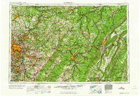
~ Pittsburgh PA topo map, 1:250000 scale, 1 X 2 Degree, Historical, 1964
Pittsburgh, Pennsylvania, USGS topographic map dated 1964.
Includes geographic coordinates (latitude and longitude). This topographic map is suitable for hiking, camping, and exploring, or framing it as a wall map.
Printed on-demand using high resolution imagery, on heavy weight and acid free paper, or alternatively on a variety of synthetic materials.
Topos available on paper, Waterproof, Poly, or Tyvek. Usually shipping rolled, unless combined with other folded maps in one order.
- Product Number: USGS-5332046
- Free digital map download (high-resolution, GeoPDF): Pittsburgh, Pennsylvania (file size: 21 MB)
- Map Size: please refer to the dimensions of the GeoPDF map above
- Weight (paper map): ca. 55 grams
- Map Type: POD USGS Topographic Map
- Map Series: HTMC
- Map Verison: Historical
- Cell ID: 68961
- Scan ID: 221427
- Woodland Tint: Yes
- Datum: Unstated
- Map Projection: Transverse Mercator
- Map published by United States Army Corps of Engineers
- Map published by United States Army
- Map Language: English
- Scanner Resolution: 600 dpi
- Map Cell Name: Pittsburgh
- Grid size: 1 X 2 Degree
- Date on map: 1964
- Map Scale: 1:250000
- Geographical region: Pennsylvania, United States
Neighboring Maps:
All neighboring USGS topo maps are available for sale online at a variety of scales.
Spatial coverage:
Topo map Pittsburgh, Pennsylvania, covers the geographical area associated the following places:
- Strongstown - Lower Whyel - Brownsville - Carrick - Coulter - Broughton - Brownstown - Port Vue - Shadow Shuttle - Black Diamond - McConnellstown - Bens Creek - Dutch Corner - Cairnbrook - Reagantown - Shieldsburg - Buena Vista - Rector - Reading Number Three - Hiller - Arch Spring - Brinkerton - Indian Springs Estates - Robindale (historical) - Lockport - Belden - Glasgow - Sandy Run - Oak Hill - Edna Number Two - Monroeville - Mount Joy - Mount Vernon - Glenshaw - Churchill Valley - Buena Vista - Spruce Creek - Colver - Neff - Krayn - Jonestown - Manor - Jamestown - Whitehall - Red Barn - Darragh - Faunce - Harbison - Vetera - Hoguetown - Laurel Mountain Village - Reitz - Donegal - South Altoona - Wissingertown - Marklesburg - Etna - Yellow Spring - Douglass - Allenvale - Marron - Kellersburg - Vintondale - Neale - Thomas Crossroads - Truxall - Fulton - Tatesville - Edgewood - Everett - Smoke Run - Millertown - Slabtown - East McKeesport - Decaturville - Garden City - North Buffalo - Allison Park - Polish Hill - Shado-Wood Village - Collinsburg - Quecreek - Dias - Cookport - Houtzdale - Foot of Ten - New Texas - Stockdale - Roxbury - Keal Run - Bakersville - Canoe Ridge - Logan - Fairfield Heights - Undercliff - Beaver Mills - Dunningtown - Northvue - Yellow Creek - Leechburg
- Map Area ID: AREA4140-80-78
- Northwest corner Lat/Long code: USGSNW41-80
- Northeast corner Lat/Long code: USGSNE41-78
- Southwest corner Lat/Long code: USGSSW40-80
- Southeast corner Lat/Long code: USGSSE40-78
- Northern map edge Latitude: 41
- Southern map edge Latitude: 40
- Western map edge Longitude: -80
- Eastern map edge Longitude: -78


