
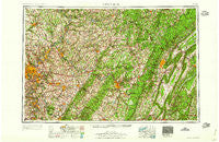
~ Pittsburgh PA topo map, 1:250000 scale, 1 X 2 Degree, Historical, 1959
Pittsburgh, Pennsylvania, USGS topographic map dated 1959.
Includes geographic coordinates (latitude and longitude). This topographic map is suitable for hiking, camping, and exploring, or framing it as a wall map.
Printed on-demand using high resolution imagery, on heavy weight and acid free paper, or alternatively on a variety of synthetic materials.
Topos available on paper, Waterproof, Poly, or Tyvek. Usually shipping rolled, unless combined with other folded maps in one order.
- Product Number: USGS-5332044
- Free digital map download (high-resolution, GeoPDF): Pittsburgh, Pennsylvania (file size: 21 MB)
- Map Size: please refer to the dimensions of the GeoPDF map above
- Weight (paper map): ca. 55 grams
- Map Type: POD USGS Topographic Map
- Map Series: HTMC
- Map Verison: Historical
- Cell ID: 68961
- Scan ID: 221426
- Woodland Tint: Yes
- Aerial Photo Year: 1941
- Datum: Unstated
- Map Projection: Transverse Mercator
- Map published by United States Army Corps of Engineers
- Map published by United States Army
- Map Language: English
- Scanner Resolution: 600 dpi
- Map Cell Name: Pittsburgh
- Grid size: 1 X 2 Degree
- Date on map: 1959
- Map Scale: 1:250000
- Geographical region: Pennsylvania, United States
Neighboring Maps:
All neighboring USGS topo maps are available for sale online at a variety of scales.
Spatial coverage:
Topo map Pittsburgh, Pennsylvania, covers the geographical area associated the following places:
- Lowber - Flowing Spring - McClarran - Morrisdale - Slickport - Milbell - Blackstone - Fawn Haven Number Two - Lavansville - Larimer - Charlies Grove - West Wilmerding - West Lebanon - Kantner - Coal Hollow - Laidig - Gallatin - Wickhaven - McBride - Llanfair - Snyder - Thomas Crossroads - Schenley Heights - Browns Crossroads - North Scottdale - Pleasantville - Ben Avon - Mount Dallas - Sunrise - Allison Park - Centennial - Eckenrode Mill - Newtown - Denbo - Lockview - Emeigh - Buckeye - Barners Hill - Llyswen - Two Lick - Saint Michael - North Fork - Bilger Rocks - Hooversville - Stockdale - Garvers Ferry - Swedetown - Ostend - Blawnox - Ardara - Shawtown - Greenwald - Great Belt - Gracey - Herminie - Brackenridge - Pavia - Swissvale - Cush Creek - Suncliff - Grafton - Grandview - McConnellstown - Twin Bridges - Thompsontown - Finleyville - Chickaree - Waterford - Chestnut Grove - Bakers Summit - Beula - New Millport - Millertown - Tanoma - McPherron - Maple Glen - Collinsburg - Frye - Cypher - Huston Run - Maple Grove - Jacktown - Loretto Road - Hartley - Huntingdon Furnace - Ekastown - Tripoli - New Texas - Layton - Saint Charles - Clover Creek - Georges Station - Century - Manor - Puttstown - Viola - Homer Gap - Scalp Level - Orchard Hill - Delmont
- Map Area ID: AREA4140-80-78
- Northwest corner Lat/Long code: USGSNW41-80
- Northeast corner Lat/Long code: USGSNE41-78
- Southwest corner Lat/Long code: USGSSW40-80
- Southeast corner Lat/Long code: USGSSE40-78
- Northern map edge Latitude: 41
- Southern map edge Latitude: 40
- Western map edge Longitude: -80
- Eastern map edge Longitude: -78


