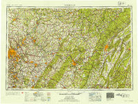
~ Pittsburgh PA topo map, 1:250000 scale, 1 X 2 Degree, Historical, 1954, updated 1954
Pittsburgh, Pennsylvania, USGS topographic map dated 1954.
Includes geographic coordinates (latitude and longitude). This topographic map is suitable for hiking, camping, and exploring, or framing it as a wall map.
Printed on-demand using high resolution imagery, on heavy weight and acid free paper, or alternatively on a variety of synthetic materials.
Topos available on paper, Waterproof, Poly, or Tyvek. Usually shipping rolled, unless combined with other folded maps in one order.
- Product Number: USGS-5332042
- Free digital map download (high-resolution, GeoPDF): Pittsburgh, Pennsylvania (file size: 18 MB)
- Map Size: please refer to the dimensions of the GeoPDF map above
- Weight (paper map): ca. 55 grams
- Map Type: POD USGS Topographic Map
- Map Series: HTMC
- Map Verison: Historical
- Cell ID: 68961
- Scan ID: 221425
- Imprint Year: 1954
- Woodland Tint: Yes
- Aerial Photo Year: 1941
- Datum: Unstated
- Map Projection: Transverse Mercator
- Map published by United States Army Corps of Engineers
- Map published by United States Army
- Map Language: English
- Scanner Resolution: 600 dpi
- Map Cell Name: Pittsburgh
- Grid size: 1 X 2 Degree
- Date on map: 1954
- Map Scale: 1:250000
- Geographical region: Pennsylvania, United States
Neighboring Maps:
All neighboring USGS topo maps are available for sale online at a variety of scales.
Spatial coverage:
Topo map Pittsburgh, Pennsylvania, covers the geographical area associated the following places:
- Shirley - Chestnut Grove - Peanut - Putneyville - Elderton - West Export - Youngwood - Elizabeth - Terrace - Oak Tree - Red Hot - Kier - Hunker - Rattigan - Foster - Blawnox - Lewisville - Knoxville - Pindleton - Brownstown - East Run - Loysburg - Ambrose - Saxton - Valier - Gracey - Nine Row - Champion - Nichola - Deanville - Gratztown - Allenvale - Industry - Bredinville - Thomas Mill - Tyrone Forge - Slickport - Morann - Hillsdale - Southmont - McConnellstown - Fairbanks - Wilbur - Port Vue - Cochrans Mill - Fox Chapel - Graceton - Belmar - Edna Number Two - Mount Pleasant - Barnes - Lookabough Corners - Sportsburg - Huston Run - Maxwell - Mascot (historical) - Froman - Blackburn (historical) - Distant - Option - Brownstown - Circleville - Morewood - Canoe Creek - Harmarville - Van Buren - Greenock - West Wilmerding - Fredericktown - Manor Heights - West Bethany - Georges Station - Burds Crossing - McHaddon - Barr Slope - Westmont - East Oakmont - Undercliff - Parkstown - Roots - Riddlesburg - Kinter Crossing - Douglass - Weltytown - Cherry Grove - Seminole - Snyder - Hill Distrct - Pikes Peak - Cunningham - Lovejoy - Ansonville - Gillespie - Sarver - Grafton - Beryl - Puritan - Flat Rock - Surgeon Hall - Webster
- Map Area ID: AREA4140-80-78
- Northwest corner Lat/Long code: USGSNW41-80
- Northeast corner Lat/Long code: USGSNE41-78
- Southwest corner Lat/Long code: USGSSW40-80
- Southeast corner Lat/Long code: USGSSE40-78
- Northern map edge Latitude: 41
- Southern map edge Latitude: 40
- Western map edge Longitude: -80
- Eastern map edge Longitude: -78

