
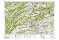
~ Harrisburg PA topo map, 1:250000 scale, 1 X 2 Degree, Historical, 1957, updated 1980
Harrisburg, Pennsylvania, USGS topographic map dated 1957.
Includes geographic coordinates (latitude and longitude). This topographic map is suitable for hiking, camping, and exploring, or framing it as a wall map.
Printed on-demand using high resolution imagery, on heavy weight and acid free paper, or alternatively on a variety of synthetic materials.
Topos available on paper, Waterproof, Poly, or Tyvek. Usually shipping rolled, unless combined with other folded maps in one order.
- Product Number: USGS-5332034
- Free digital map download (high-resolution, GeoPDF): Harrisburg, Pennsylvania (file size: 21 MB)
- Map Size: please refer to the dimensions of the GeoPDF map above
- Weight (paper map): ca. 55 grams
- Map Type: POD USGS Topographic Map
- Map Series: HTMC
- Map Verison: Historical
- Cell ID: 68815
- Scan ID: 171813
- Imprint Year: 1980
- Woodland Tint: Yes
- Photo Revision Year: 1969
- Aerial Photo Year: 1952
- Field Check Year: 1957
- Datum: NAD27
- Map Projection: Transverse Mercator
- Map published by: Military, Other
- Map Language: English
- Scanner Resolution: 600 dpi
- Map Cell Name: Harrisburg
- Grid size: 1 X 2 Degree
- Date on map: 1957
- Map Scale: 1:250000
- Geographical region: Pennsylvania, United States
Neighboring Maps:
All neighboring USGS topo maps are available for sale online at a variety of scales.
Spatial coverage:
Topo map Harrisburg, Pennsylvania, covers the geographical area associated the following places:
- Grandview Heights - Red Bank - Leola - Bunches - Shumans - Belleville - Windsor Manor - Middle Creek (historical) - Reamstown - Longsdorf - Mascot - Frisbie - Big Spring - Dornsife - Ferndale - Green Valley Gardens - Perulack - Grovania - Hays Grove - Locust Lane Gardens - Allen - Highland Park - Port Clinton - Locust Point - Swatara Crest - Roxbury - Monterey - Zion - Manada Gap - Mooresburg - Mount Zion - Shartlesville - Donation - Strouptown - Vineyard - Greble - Juniata Furnace - Glenworth - Excelsior - Sacramento - Shenandoah Heights - Conewago - Glendower - Millport - Fredericksburg - Evendale - Paxinos - Freeport Mills - Pleasant View - Landingville - Lawn - Eden Heights - Lantz - Middlesex - Dark Water - Horningford - Oakland Mills - Hanover Hills - Oakville - Dauphin - Pillow - West Hill - Shadle - Little Roundtop - Vera Cruz - Frogtown - Sunnyland - Leaman Place - Garden Hills - Wood Ridge Manor - Snydertown - Malta - Martins Crossroads - Pine Grove - York Haven - Colonial Hills - College Park - Loysville - Catalina - Walnut - Airydale - Meiser Station - Valley View - Pleasant Gap - Ashland - Alexander Springs - Central City - Adams - Klondyke - Lincoln - Twin Grove Park - Hockersville - Muir - Shenandoah - Pinola - Mabel - Valley View - Hazleton Junction - Upper Lawn - Speedwell
- Map Area ID: AREA4140-78-76
- Northwest corner Lat/Long code: USGSNW41-78
- Northeast corner Lat/Long code: USGSNE41-76
- Southwest corner Lat/Long code: USGSSW40-78
- Southeast corner Lat/Long code: USGSSE40-76
- Northern map edge Latitude: 41
- Southern map edge Latitude: 40
- Western map edge Longitude: -78
- Eastern map edge Longitude: -76


