
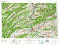
~ Harrisburg PA topo map, 1:250000 scale, 1 X 2 Degree, Historical, 1957, updated 1966
Harrisburg, Pennsylvania, USGS topographic map dated 1957.
Includes geographic coordinates (latitude and longitude). This topographic map is suitable for hiking, camping, and exploring, or framing it as a wall map.
Printed on-demand using high resolution imagery, on heavy weight and acid free paper, or alternatively on a variety of synthetic materials.
Topos available on paper, Waterproof, Poly, or Tyvek. Usually shipping rolled, unless combined with other folded maps in one order.
- Product Number: USGS-5332030
- Free digital map download (high-resolution, GeoPDF): Harrisburg, Pennsylvania (file size: 19 MB)
- Map Size: please refer to the dimensions of the GeoPDF map above
- Weight (paper map): ca. 55 grams
- Map Type: POD USGS Topographic Map
- Map Series: HTMC
- Map Verison: Historical
- Cell ID: 68815
- Scan ID: 171811
- Imprint Year: 1966
- Woodland Tint: Yes
- Field Check Year: 1957
- Datum: Unstated
- Map Projection: Transverse Mercator
- Map published by United States Geological Survey
- Map published by United States Army Corps of Engineers
- Map published by United States Army
- Map Language: English
- Scanner Resolution: 600 dpi
- Map Cell Name: Harrisburg
- Grid size: 1 X 2 Degree
- Date on map: 1957
- Map Scale: 1:250000
- Geographical region: Pennsylvania, United States
Neighboring Maps:
All neighboring USGS topo maps are available for sale online at a variety of scales.
Spatial coverage:
Topo map Harrisburg, Pennsylvania, covers the geographical area associated the following places:
- Millheim - Bowmans - Springford Village - Amberson Valley Estates - Klondyke - Steelton - Outwood - Decorum - Wildwood - Big Mine Run - Englewood - College Park - Mannsville - Pitman - Cowan - Dover - Harvest Hills - Houserville - Ferndale - Circle Ville - Rushtown - Laurel Woods - Fannettsburg - Bush Addition - Robesonia - Woodycrest - Ramblewood - Beaverdam - Wilburton Number One - Billmeyer - Walnut - Bressler - Ridge Acres - Concord - Coyle - Hauckville - Mountain Dale - Wilburton - Landingville - Eastland Hills - Ingleby - Highland Park - Locust Run - Boiling Springs - Union Water Works - Tower City - Woodridge Estates - Twin Lakes - Turkey Run - Kingwood - Lower Brownville - Reistville - Rosegarden - Gowen Breaker Station - Centerville - Elliotts Mill - West William Penn - Bunkertown - Sundy Place - Pardee - Montello - Locke Mills - Little Kansas - Greenfield - Lumber City - Springville - Trenton - Harmony Grove - Witmer - Pleasant Hill - Kelayres - Smullton - Riverside - Bellaire - Erney - Shumans - Knobville - Freeburg - Weishample - Uno - Caketown - Oak Hall - Park Place - Poplar Gardens - Lost Creek - Wiconisco - Matamoras - Lavelle - Kutztown - Pleasant Gap - Mount Carmel - Ranshaw - Juniata Terrace - Cocalico - Cedar Hill - Center Square - Mount Laffee - Hillsdale Acres - Smoketown - Exmoor
- Map Area ID: AREA4140-78-76
- Northwest corner Lat/Long code: USGSNW41-78
- Northeast corner Lat/Long code: USGSNE41-76
- Southwest corner Lat/Long code: USGSSW40-78
- Southeast corner Lat/Long code: USGSSE40-76
- Northern map edge Latitude: 41
- Southern map edge Latitude: 40
- Western map edge Longitude: -78
- Eastern map edge Longitude: -76


