
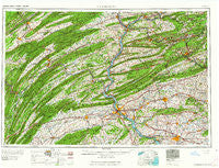
~ Harrisburg PA topo map, 1:250000 scale, 1 X 2 Degree, Historical, 1964, updated 1964
Harrisburg, Pennsylvania, USGS topographic map dated 1964.
Includes geographic coordinates (latitude and longitude). This topographic map is suitable for hiking, camping, and exploring, or framing it as a wall map.
Printed on-demand using high resolution imagery, on heavy weight and acid free paper, or alternatively on a variety of synthetic materials.
Topos available on paper, Waterproof, Poly, or Tyvek. Usually shipping rolled, unless combined with other folded maps in one order.
- Product Number: USGS-5332028
- Free digital map download (high-resolution, GeoPDF): Harrisburg, Pennsylvania (file size: 20 MB)
- Map Size: please refer to the dimensions of the GeoPDF map above
- Weight (paper map): ca. 55 grams
- Map Type: POD USGS Topographic Map
- Map Series: HTMC
- Map Verison: Historical
- Cell ID: 68815
- Scan ID: 171810
- Imprint Year: 1964
- Woodland Tint: Yes
- Field Check Year: 1957
- Datum: Unstated
- Map Projection: Transverse Mercator
- Map published by United States Army Corps of Engineers
- Map published by United States Army
- Map Language: English
- Scanner Resolution: 600 dpi
- Map Cell Name: Harrisburg
- Grid size: 1 X 2 Degree
- Date on map: 1964
- Map Scale: 1:250000
- Geographical region: Pennsylvania, United States
Neighboring Maps:
All neighboring USGS topo maps are available for sale online at a variety of scales.
Spatial coverage:
Topo map Harrisburg, Pennsylvania, covers the geographical area associated the following places:
- Augustaville - Fisherdale - Landis Valley - Steins - Cobblesville - Windsor Park - Pine Hall - McCoysville - Grantville - Kistler - Eshcol - Elliottsburg - Salunga - Halifax - Paxtang Manor - Millersburg - Mount Allen Estates - Diamondtown - Tamanend - Cleversburg Junction - Springville - Vintage - Mount Pleasant - Belleville - Fort Couch - Silverton - Little Hollywood Mobile Home Park - East Hanover - Montello - Wila - Country Club West - Pleasant Gap - Walnut - Blacklog - Tallowyck - Shreiners - Killinger - Old Fort - Camp Hill - Donaldson - Nacetown - Pleasant Hill - Mountain View Acres - New Holland - Honey - West Cameron - Barnitz - Strouptown - Bareville - Caketown - David Manor - Shiremanstown - Haucks - Stricklerstown - Bloomingdale - Florin - Chickies - Colonial Wood - Fern Glen - Grier City - Poplar Grove - Saint Nicholas - Nossville - Long Lane Acres - Pine Junction - Fairview Park - Annville - Harwood - Fearnot - Fairland - Millway - Linden Hall - Glenn Acres - Schlusser - Culbertson - Selinsgrove - Wintersville - Paxton - Brandonville - Greason - Bowmans - Center Square - Gowen City - Reed - Houck Manor - Enola - Penryn - West Lawn - Roseburg - Primrose - Raven Run - Mountain Dale - Pleasant View - Vinemont - Otterbein - Ferndale - Colebrook - Peace Church - Springhaven - Eden
- Map Area ID: AREA4140-78-76
- Northwest corner Lat/Long code: USGSNW41-78
- Northeast corner Lat/Long code: USGSNE41-76
- Southwest corner Lat/Long code: USGSSW40-78
- Southeast corner Lat/Long code: USGSSE40-76
- Northern map edge Latitude: 41
- Southern map edge Latitude: 40
- Western map edge Longitude: -78
- Eastern map edge Longitude: -76


