
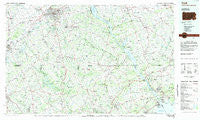
~ York PA topo map, 1:100000 scale, 30 X 60 Minute, Historical, 1983, updated 1984
York, Pennsylvania, USGS topographic map dated 1983.
Includes geographic coordinates (latitude and longitude). This topographic map is suitable for hiking, camping, and exploring, or framing it as a wall map.
Printed on-demand using high resolution imagery, on heavy weight and acid free paper, or alternatively on a variety of synthetic materials.
Topos available on paper, Waterproof, Poly, or Tyvek. Usually shipping rolled, unless combined with other folded maps in one order.
- Product Number: USGS-5332012
- Free digital map download (high-resolution, GeoPDF): York, Pennsylvania (file size: 17 MB)
- Map Size: please refer to the dimensions of the GeoPDF map above
- Weight (paper map): ca. 55 grams
- Map Type: POD USGS Topographic Map
- Map Series: HTMC
- Map Verison: Historical
- Cell ID: 68625
- Scan ID: 222630
- Imprint Year: 1984
- Woodland Tint: Yes
- Aerial Photo Year: 1982
- Edit Year: 1983
- Datum: NAD27
- Map Projection: Universal Transverse Mercator
- Planimetric: Yes
- Map published by United States Geological Survey
- Map Language: English
- Scanner Resolution: 600 dpi
- Map Cell Name: York
- Grid size: 30 X 60 Minute
- Date on map: 1983
- Map Scale: 1:100000
- Geographical region: Pennsylvania, United States
Neighboring Maps:
All neighboring USGS topo maps are available for sale online at a variety of scales.
Spatial coverage:
Topo map York, Pennsylvania, covers the geographical area associated the following places:
- Union - Campus Valley Estates - Sharretts Ridge - Lawndale Acres - Appleton - Swan Creek - Burkley Manor - Dayspring Estates - Gwendale - Stringtown - Rockhill - Darlington Mobile Home Park - Green Valley - Seven Cedars - Ascot Estates - Reese - Camelot - Green Ridge - Cape Horn South - Nottingham Fields - Brandywine Farms - Happy Knoll - Hampstead Valley - B and J Trailer Park - Woodlawn Mobile Home Estates - Tannery - Fairwood of Hunt Valley - Chapel View - Farmington - Heritage Estates - Baldwin Hills - Gibson - Albantown - Todd Estates - West Bangor - Peaceful Valley - Meadow Springs - Hillside - Hoerr - Quail Hills - Lower Hopewell - Park Ridge Estates - Drybranch - Bright Oaks - Fairmont - Wilshire Hills - Colemanville - Hill-N-Dale - East Prospect - Ferncliff - Putnam Hill - Corbett - Bacon Mill - Locust Spring - Highlands - Running Brook Mobile Home Park - Parkwood - Level Terrace - Royal Heights - Prettyboy Trails - Unicorn - Red Lion - Herman Heights - Brigadoon - Clear Spring Estates - Brierwood - Leibharts Corner - Roland Place - Highfield Park - Sweet Air Manor - Putnam View Estates - Raven Run - Marborough West - Swan Harbour Dell Mobile Home Park - Lapidum - Proctors Seat - Rolling Green - White Oak - Beverly Hills - Springvale - Port Heights - Fordville - Trump - Oak Shade - Melrose - Young Mans Fancy - Harford Hunt Manor - Mount Vernon - Hill Land - Locksley Manor - Gap - Dolf - Tweedale - Madonna - Woodridge Manor - Abbottstown - Braemar - Brilhart Terrace - Rayville - Nobles Mill Estates - Slate Hill
- Map Area ID: AREA4039.5-77-76
- Northwest corner Lat/Long code: USGSNW40-77
- Northeast corner Lat/Long code: USGSNE40-76
- Southwest corner Lat/Long code: USGSSW39.5-77
- Southeast corner Lat/Long code: USGSSE39.5-76
- Northern map edge Latitude: 40
- Southern map edge Latitude: 39.5
- Western map edge Longitude: -77
- Eastern map edge Longitude: -76


