
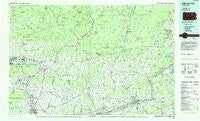
~ Williamsport East PA topo map, 1:100000 scale, 30 X 60 Minute, Historical, 1984, updated 1985
Williamsport East, Pennsylvania, USGS topographic map dated 1984.
Includes geographic coordinates (latitude and longitude). This topographic map is suitable for hiking, camping, and exploring, or framing it as a wall map.
Printed on-demand using high resolution imagery, on heavy weight and acid free paper, or alternatively on a variety of synthetic materials.
Topos available on paper, Waterproof, Poly, or Tyvek. Usually shipping rolled, unless combined with other folded maps in one order.
- Product Number: USGS-5332004
- Free digital map download (high-resolution, GeoPDF): Williamsport East, Pennsylvania (file size: 19 MB)
- Map Size: please refer to the dimensions of the GeoPDF map above
- Weight (paper map): ca. 55 grams
- Map Type: POD USGS Topographic Map
- Map Series: HTMC
- Map Verison: Historical
- Cell ID: 68594
- Scan ID: 223670
- Imprint Year: 1985
- Woodland Tint: Yes
- Aerial Photo Year: 1981
- Edit Year: 1984
- Datum: NAD27
- Map Projection: Universal Transverse Mercator
- Planimetric: Yes
- Map published by United States Geological Survey
- Map Language: English
- Scanner Resolution: 600 dpi
- Map Cell Name: Williamsport East
- Grid size: 30 X 60 Minute
- Date on map: 1984
- Map Scale: 1:100000
- Geographical region: Pennsylvania, United States
Neighboring Maps:
All neighboring USGS topo maps are available for sale online at a variety of scales.
Spatial coverage:
Topo map Williamsport East, Pennsylvania, covers the geographical area associated the following places:
- Stull - Newport Center - Chippewa - Bryan Mill - Sereno - Asbury - Bella Vista - Proctor - Feys Grove - Jerseytown - Biggerstown - Muncy - New Columbus - Dogtown - South Williamsport - McEwensville - Kenmar - Briggsville - Maple Grove - Ringdale - Noxen - Spring Garden - Hetlerville - Eagles Mere - Saint Johns - Montgomery - Sonestown - Weintz - Lairdsville - Fritz (historical) - Harveyville - Montoursville - Pikes Creek - Villa Grove - Lehman - Saegers - Nordmont - Muhlenburg - Summer Hill - Hallwood - Ogdonia - Evansville - Lime Bluff - Slocum Corners - Washingtonville - Jackson - Coles Creek - Hess Island - Meeker - Springtown - Oak Grove - Muncy Valley - Laubach - Millertown - Hobbie - Hettesheimer Corners - Stairville - Satterfield - Welliversville - Derry - Ottawa - Foundryville - Lopez - Almedia - Kyttle - Pleasant Valley - Sheatown - Marshall Hollow - Picture Rocks - Hughesville - Plunkett - Kasson Brook - Dieffenbach - Shickshinny - Talmer - Bernice - Beech Glen - Old Furnace - Long Brook - Shawanese - Willow Springs - Ripple - Warrensville - Dorrance - Kellyburg - Central - Calvert - Glen Mawr - Derrs - West Nanticoke - Berwick - Grassmere Park - Allenwood - Cease Mills - East Berwick - Ricketts - Ruggles - Farragut - Laketon - California
- Map Area ID: AREA41.541-77-76
- Northwest corner Lat/Long code: USGSNW41.5-77
- Northeast corner Lat/Long code: USGSNE41.5-76
- Southwest corner Lat/Long code: USGSSW41-77
- Southeast corner Lat/Long code: USGSSE41-76
- Northern map edge Latitude: 41.5
- Southern map edge Latitude: 41
- Western map edge Longitude: -77
- Eastern map edge Longitude: -76


