
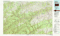
~ Wellsboro PA topo map, 1:100000 scale, 30 X 60 Minute, Historical, 1981, updated 1982
Wellsboro, Pennsylvania, USGS topographic map dated 1981.
Includes geographic coordinates (latitude and longitude). This topographic map is suitable for hiking, camping, and exploring, or framing it as a wall map.
Printed on-demand using high resolution imagery, on heavy weight and acid free paper, or alternatively on a variety of synthetic materials.
Topos available on paper, Waterproof, Poly, or Tyvek. Usually shipping rolled, unless combined with other folded maps in one order.
- Product Number: USGS-5332002
- Free digital map download (high-resolution, GeoPDF): Wellsboro, Pennsylvania (file size: 28 MB)
- Map Size: please refer to the dimensions of the GeoPDF map above
- Weight (paper map): ca. 55 grams
- Map Type: POD USGS Topographic Map
- Map Series: HTMC
- Map Verison: Historical
- Cell ID: 68566
- Scan ID: 222457
- Imprint Year: 1982
- Woodland Tint: Yes
- Aerial Photo Year: 1977
- Edit Year: 1981
- Datum: NAD27
- Map Projection: Universal Transverse Mercator
- Map published by United States Geological Survey
- Map Language: English
- Scanner Resolution: 600 dpi
- Map Cell Name: Wellsboro
- Grid size: 30 X 60 Minute
- Date on map: 1981
- Map Scale: 1:100000
- Geographical region: Pennsylvania, United States
Neighboring Maps:
All neighboring USGS topo maps are available for sale online at a variety of scales.
Spatial coverage:
Topo map Wellsboro, Pennsylvania, covers the geographical area associated the following places:
- Doane - Mount Pleasant - Austinburg - Ayers Hill - Lambs Creek - Antrim - Potter Brook - Marsh Creek - Owassee - Jamison - Coolidge Hollow - Rexford - Purple Brook (historical) - Tioga Junction - Ansonia - Harrison Valley - River West - Pine - Shinglebury - Frinks - Beeman - Olmsville - Fox Hill - Genesee - College - East Point - Azelta - Klondike (historical) - Cedar Pines - Draper - Loucks Mills - Nauvoo - Tompkins - Harrison - Five Points - Pritchard (historical) - Logue - Leetonia - Liberty - Maple Hill - Borie - Nelson - North Fork - Waltrous - West Bingham - Gaines Junction - East Lawrence - Plank - Morris Run - Cowanesque - Knoxville - Farmington Hill - North Bingham - Mill Creek - Galeton - Gurnee - Newfield Junction - Wellsboro - Reynoldstown - Hartsfield - Telescope - Mardin - Sylvester - Short Run - Manhattan - Brooklyn - Colesburg - Oleona - House Landing Strip - Shortsville - Conrad - Elbridge - Lorenton - Andrews Settlement - Roundtop - Blossburg - Three Springs Run - Tiadaghton - Sebring - Morris - Mansfield - Gaines - Brookfield - Little Marsh - Bingham Center - Christian Hill - Oregon Hill - Mitchell Creek - Heise Run - Westfield - Sabinsville - Tioga - Stokesdale - Hammond - Lymansville - Thumptown - Corbett - Kellytown - Cedar Run - Kinney
- Map Area ID: AREA4241.5-78-77
- Northwest corner Lat/Long code: USGSNW42-78
- Northeast corner Lat/Long code: USGSNE42-77
- Southwest corner Lat/Long code: USGSSW41.5-78
- Southeast corner Lat/Long code: USGSSE41.5-77
- Northern map edge Latitude: 42
- Southern map edge Latitude: 41.5
- Western map edge Longitude: -78
- Eastern map edge Longitude: -77


