
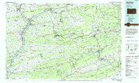
~ Sunbury PA topo map, 1:100000 scale, 30 X 60 Minute, Historical, 1984, updated 1985
Sunbury, Pennsylvania, USGS topographic map dated 1984.
Includes geographic coordinates (latitude and longitude). This topographic map is suitable for hiking, camping, and exploring, or framing it as a wall map.
Printed on-demand using high resolution imagery, on heavy weight and acid free paper, or alternatively on a variety of synthetic materials.
Topos available on paper, Waterproof, Poly, or Tyvek. Usually shipping rolled, unless combined with other folded maps in one order.
- Product Number: USGS-5331994
- Free digital map download (high-resolution, GeoPDF): Sunbury, Pennsylvania (file size: 19 MB)
- Map Size: please refer to the dimensions of the GeoPDF map above
- Weight (paper map): ca. 55 grams
- Map Type: POD USGS Topographic Map
- Map Series: HTMC
- Map Verison: Historical
- Cell ID: 68426
- Scan ID: 224020
- Imprint Year: 1985
- Woodland Tint: Yes
- Aerial Photo Year: 1983
- Edit Year: 1984
- Datum: NAD27
- Map Projection: Universal Transverse Mercator
- Planimetric: Yes
- Map published by United States Geological Survey
- Map Language: English
- Scanner Resolution: 600 dpi
- Map Cell Name: Sunbury
- Grid size: 30 X 60 Minute
- Date on map: 1984
- Map Scale: 1:100000
- Geographical region: Pennsylvania, United States
Neighboring Maps:
All neighboring USGS topo maps are available for sale online at a variety of scales.
Spatial coverage:
Topo map Sunbury, Pennsylvania, covers the geographical area associated the following places:
- Stonington - Aucheys - Mechanicsville - Tuscarora - Bear Run Junction - Buck Mountain - Danville - Ellen Gowan - Greenfield - Shamokin - Byrnsville - Mill Grove - Otto - Zion Grove - Winfield - Frackville Junction - Bucknell - Hepler - Maple Hill - Independence - Ridgeville - Hamilton - Marlin - Harwood - Trevorton - Chapman - Rough and Ready - Arnots Addition - Quitman - Pallas - Mabel - Delano - Rupert - Excelsior - Big Mountain - Numidia - West Hamburg - Weston - Forestville - Seltzer - Berrysburg - Raricks - Grovania - Snydertown - Trenton - Monticello - Mahanoy Plane - Hebe - Pleasant Valley - West Cameron - East Mines - Marion Heights - New Berlin - Adamsdale - Natalie - Port Carbon - Rock Glen - Mausdale - Millers Corner - Paradise - Fern Glen - Port Trevorton - Pleasant Hills - Kneass - Mount Patrick - Reed - Shoemakers - Urban - Roedersville - Elizabethville - Salem - Selinsgrove - Mount Pleasant - Tamanend - Glenworth - Hollars Hill - Park Crest - Lofty - Kulpmont - Newtown - Kapp - Slabtown - Buck Run - Hosensock - Pitman - Uniontown - Hills Terrace - Breezy Acres - Maryd - Bear Gap - Beckville - Pensyls Mill - Irving - Greenbrier - East Bloomsburg - Moyers - Hoffer - Loyalton - Hazleton Junction - Williamstown
- Map Area ID: AREA4140.5-77-76
- Northwest corner Lat/Long code: USGSNW41-77
- Northeast corner Lat/Long code: USGSNE41-76
- Southwest corner Lat/Long code: USGSSW40.5-77
- Southeast corner Lat/Long code: USGSSE40.5-76
- Northern map edge Latitude: 41
- Southern map edge Latitude: 40.5
- Western map edge Longitude: -77
- Eastern map edge Longitude: -76


