
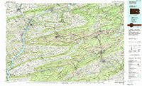
~ Sunbury PA topo map, 1:100000 scale, 30 X 60 Minute, Historical, 1984, updated 1988
Sunbury, Pennsylvania, USGS topographic map dated 1984.
Includes geographic coordinates (latitude and longitude). This topographic map is suitable for hiking, camping, and exploring, or framing it as a wall map.
Printed on-demand using high resolution imagery, on heavy weight and acid free paper, or alternatively on a variety of synthetic materials.
Topos available on paper, Waterproof, Poly, or Tyvek. Usually shipping rolled, unless combined with other folded maps in one order.
- Product Number: USGS-5331992
- Free digital map download (high-resolution, GeoPDF): Sunbury, Pennsylvania (file size: 29 MB)
- Map Size: please refer to the dimensions of the GeoPDF map above
- Weight (paper map): ca. 55 grams
- Map Type: POD USGS Topographic Map
- Map Series: HTMC
- Map Verison: Historical
- Cell ID: 68426
- Scan ID: 222078
- Imprint Year: 1988
- Woodland Tint: Yes
- Aerial Photo Year: 1983
- Edit Year: 1984
- Datum: NAD27
- Map Projection: Universal Transverse Mercator
- Map published by United States Geological Survey
- Map Language: English
- Scanner Resolution: 600 dpi
- Map Cell Name: Sunbury
- Grid size: 30 X 60 Minute
- Date on map: 1984
- Map Scale: 1:100000
- Geographical region: Pennsylvania, United States
Neighboring Maps:
All neighboring USGS topo maps are available for sale online at a variety of scales.
Spatial coverage:
Topo map Sunbury, Pennsylvania, covers the geographical area associated the following places:
- Keefers - Meiserville - Chulasky - Greenfield - Belmont - Frackville Junction - Rock Glen - Cressona - Reservoir Heights - Harwood - Fishers Ferry - Byrnsville - Stonington - Otto - Reevesdale - Hills Terrace - Klines Grove - Verdilla - Sheridan - Big Mountain - Rushtown - Wetherill Junction - Fisherville - Mountain Grove - Renningers - Glen Carbon - Pine Grove - Outwood - Pattersonville - Gum Run - Good Spring - Hollars Hill - Loyalton - Bear Run Junction - Glenworth - Elysburg - Shoentown - Leck Kill - Shamrock - Zerbe - Humboldt - Brookside - Winfield - Dark Water - Mahanoy City - Helfenstein - Trenton - Mowry - New Castle - Rausch Creek - Kelayres - Newton Junction - East Mahanoy Junction - Elizabethville - Roaring Creek - West William Penn - Hazleton Junction - Locust Gap - Craigs - Seltzer - Hegins - Cameron - East Mines - Dietrich - Lower Brownville - Forestville - Strong - Sacramento - Dogtown - Diamondtown - Millersburg - Independence - Mount Pleasant - Beckville - Mooresburg - Edgewood - Cartin - Adamsdale - Kaseville - Wolverton - Cameron - Numidia - Keffers - Park Place - Boydtown - Oak Park - Union Corner - Mausdale - Cumbola - Duncott - Selinsgrove - Krebs - Boston Run - De Turksville - Mahantango - Maizeville - Auburn - Orwigsburg - Lewisburg - Pleasant Hills
- Map Area ID: AREA4140.5-77-76
- Northwest corner Lat/Long code: USGSNW41-77
- Northeast corner Lat/Long code: USGSNE41-76
- Southwest corner Lat/Long code: USGSSW40.5-77
- Southeast corner Lat/Long code: USGSSE40.5-76
- Northern map edge Latitude: 41
- Southern map edge Latitude: 40.5
- Western map edge Longitude: -77
- Eastern map edge Longitude: -76


