
~ State College PA topo map, 1:100000 scale, 30 X 60 Minute, Historical, 1988, updated 1989
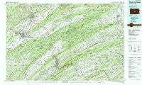
State College, Pennsylvania, USGS topographic map dated 1988.
Includes geographic coordinates (latitude and longitude). This topographic map is suitable for hiking, camping, and exploring, or framing it as a wall map.
Printed on-demand using high resolution imagery, on heavy weight and acid free paper, or alternatively on a variety of synthetic materials.
Topos available on paper, Waterproof, Poly, or Tyvek. Usually shipping rolled, unless combined with other folded maps in one order.
- Product Number: USGS-5331990
- Free digital map download (high-resolution, GeoPDF): State College, Pennsylvania (file size: 27 MB)
- Map Size: please refer to the dimensions of the GeoPDF map above
- Weight (paper map): ca. 55 grams
- Map Type: POD USGS Topographic Map
- Map Series: HTMC
- Map Verison: Historical
- Cell ID: 68408
- Scan ID: 223994
- Imprint Year: 1989
- Woodland Tint: Yes
- Aerial Photo Year: 1985
- Edit Year: 1988
- Datum: NAD27
- Map Projection: Universal Transverse Mercator
- Map published by United States Geological Survey
- Map Language: English
- Scanner Resolution: 600 dpi
- Map Cell Name: State College
- Grid size: 30 X 60 Minute
- Date on map: 1988
- Map Scale: 1:100000
- Geographical region: Pennsylvania, United States
Neighboring Maps:
All neighboring USGS topo maps are available for sale online at a variety of scales.
Spatial coverage:
Topo map State College, Pennsylvania, covers the geographical area associated the following places:
- Walnut - Krumrine - Panorama Village - Stevens - Forest Hill - McAlevys Fort - Beaver Springs - Paintersville - Linden Hall - Burnham - Rockville - Rebersburg - Overlook Heights - Johnstown - Coon Hunter - Laurelton - Rager Summit - Wildwood - Oriental - Red Bank - Strodes Mills - Spring Bank - Green Grove - Hawstone - Potters Mills - Wagner - Big Spring - Loschs - Harris Acres - Tusseyville - Milroy - Fairbrook - Oakland Mills - Coleville - Matternville - Snydertown - Bunkertown - Smullton - Fishermans Paradise - Richfield - Runville - McClure - Milesburg - Mount Eagle - Fiedler - Oak Hall - Mingoville - Reward - Martins Crossroads - Tuscarora - Wardville - Buffalo Run - Nekoda - Unionville - Ramblewood - Centerville - Soradoville - Zion - Mifflinburg - University Park - Cowan - Rockspring - Roseann - Bannerville - Axemann - Cuba Mills - Bloomsdorf - Troxelville - Juniata Terrace - Vandyke - Pleasant Grove - Mount Pleasant - Millerstown - Boalsburg - Farmers Mills - Lowell - Jericho Mills - Honey Creek - Sharpsburg - Middleburg - Musser - Evendale - Dale Summit - Alfarata - Fetzertown - Goodville - Waddle - Port Royal - Stony Run - Pine Grove Mills - Donation - Camp Hironimus - Anderson - Roundtop - Jackson Corner - Hunter Park - Lemont - Cedar Hill - Lockport - Poe Mills (historical)
- Map Area ID: AREA4140.5-78-77
- Northwest corner Lat/Long code: USGSNW41-78
- Northeast corner Lat/Long code: USGSNE41-77
- Southwest corner Lat/Long code: USGSSW40.5-78
- Southeast corner Lat/Long code: USGSSE40.5-77
- Northern map edge Latitude: 41
- Southern map edge Latitude: 40.5
- Western map edge Longitude: -78
- Eastern map edge Longitude: -77


