
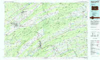
~ State College PA topo map, 1:100000 scale, 30 X 60 Minute, Historical, 1984, updated 1985
State College, Pennsylvania, USGS topographic map dated 1984.
Includes geographic coordinates (latitude and longitude). This topographic map is suitable for hiking, camping, and exploring, or framing it as a wall map.
Printed on-demand using high resolution imagery, on heavy weight and acid free paper, or alternatively on a variety of synthetic materials.
Topos available on paper, Waterproof, Poly, or Tyvek. Usually shipping rolled, unless combined with other folded maps in one order.
- Product Number: USGS-5331988
- Free digital map download (high-resolution, GeoPDF): State College, Pennsylvania (file size: 17 MB)
- Map Size: please refer to the dimensions of the GeoPDF map above
- Weight (paper map): ca. 55 grams
- Map Type: POD USGS Topographic Map
- Map Series: HTMC
- Map Verison: Historical
- Cell ID: 68408
- Scan ID: 223991
- Imprint Year: 1985
- Woodland Tint: Yes
- Aerial Photo Year: 1979
- Edit Year: 1984
- Datum: NAD27
- Map Projection: Universal Transverse Mercator
- Planimetric: Yes
- Map published by United States Geological Survey
- Map Language: English
- Scanner Resolution: 600 dpi
- Map Cell Name: State College
- Grid size: 30 X 60 Minute
- Date on map: 1984
- Map Scale: 1:100000
- Geographical region: Pennsylvania, United States
Neighboring Maps:
All neighboring USGS topo maps are available for sale online at a variety of scales.
Spatial coverage:
Topo map State College, Pennsylvania, covers the geographical area associated the following places:
- Seven Stars - Glen Iron - Belltown - Fishermans Paradise - Wardville - Yarnell - Struble - Park Hills - Loschs - Poe Mills (historical) - Shrader - Nittany - Honey Creek - Gimberlings Mill - Stony Run - Krumrine - Millmont - Rand - Sharpsburg - Lockport - Hawstone - Fillmore - Mount Pleasant - Lemont - Jackson Corner - Vira - Red Mill - Lowell - Little Roundtop - Mifflintown - White Springs - Green Grove - Cherry Run - Allensville - Potters Mills - Manor Hill - Harris Acres - Matternville - Benfer - Tusseyville - Oak Hall - Evendale - Coleville - Oriental - Swales - Pleasant View - Soradoville - Kellerville - Hartleton - University Park - Centre Hill - Ingleby - Monroe Furnace - Central City - Overlook Heights - Paxtonville - Bannerville - Pleasant Grove - Wolfs Store - Anderson - Cottage - Old Port - Nook - Lyonstown - Klondyke - Park View Heights - Shingletown - Alexander Springs - Hublersburg - Denholm - McAlevys Fort - Lumber City - Mount Pleasant - Dry Top - Woodland - Penn Hall - Cocolamus - Curtin - McClure - Horningford - Donnally Mills - Reedsville - Dale Summit - Beaverdam - Thompsontown Station - Mount Pleasant Mills - Port Royal - Lewistown - Arch Rock - Bunkertown - Siglerville - Knousetown - Livonia - Rockville - Coburn - Mifflin - Dalevue - Madisonburg - Richfield - Milroy
- Map Area ID: AREA4140.5-78-77
- Northwest corner Lat/Long code: USGSNW41-78
- Northeast corner Lat/Long code: USGSNE41-77
- Southwest corner Lat/Long code: USGSSW40.5-78
- Southeast corner Lat/Long code: USGSSE40.5-77
- Northern map edge Latitude: 41
- Southern map edge Latitude: 40.5
- Western map edge Longitude: -78
- Eastern map edge Longitude: -77


