
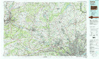
~ Reading PA topo map, 1:100000 scale, 30 X 60 Minute, Historical, 1984, updated 1988
Reading, Pennsylvania, USGS topographic map dated 1984.
Includes geographic coordinates (latitude and longitude). This topographic map is suitable for hiking, camping, and exploring, or framing it as a wall map.
Printed on-demand using high resolution imagery, on heavy weight and acid free paper, or alternatively on a variety of synthetic materials.
Topos available on paper, Waterproof, Poly, or Tyvek. Usually shipping rolled, unless combined with other folded maps in one order.
- Product Number: USGS-5331982
- Free digital map download (high-resolution, GeoPDF): Reading, Pennsylvania (file size: 27 MB)
- Map Size: please refer to the dimensions of the GeoPDF map above
- Weight (paper map): ca. 55 grams
- Map Type: POD USGS Topographic Map
- Map Series: HTMC
- Map Verison: Historical
- Cell ID: 68216
- Scan ID: 223842
- Imprint Year: 1988
- Woodland Tint: Yes
- Visual Version Number: 1
- Aerial Photo Year: 1981
- Edit Year: 1984
- Datum: NAD27
- Map Projection: Universal Transverse Mercator
- Map published by United States Geological Survey
- Map Language: English
- Scanner Resolution: 600 dpi
- Map Cell Name: Reading
- Grid size: 30 X 60 Minute
- Date on map: 1984
- Map Scale: 1:100000
- Geographical region: Pennsylvania, United States
Neighboring Maps:
All neighboring USGS topo maps are available for sale online at a variety of scales.
Spatial coverage:
Topo map Reading, Pennsylvania, covers the geographical area associated the following places:
- Abrahams - Rushland - Quakertown - Mechanicsville - Limekiln - Joanna Heights - Arlingham - Wyomissing - Blue Bell Glenn - Pleasant Valley Homes - Phoenixville - Providence Green - Moorehall at Valley Forge - Garrett Hill - Bradford Hills - Elkins Park Gardens - Westridge - Pennwyn - Rydal Green - Corsons - Valley Forge Meadows - Bonair - Pilgerts - Wetherills Corner - Victoria Glen - Daylesford - Providence View - Franklinville - Zionsville - Rosedale - Finland - Whitemarsh - Summerdale - Hatfield - Pin Oak Estates - Rydal - Village Builders - Saw Mill Valley - Cynwyd Estates - Valley Forge Acres - Rahns - Ridgewood - Acorn - Smoketown - Sunny Ayr Estates - Clearview Heights - Gwynedd Estates - Sunrise - Hershey Mill - Cedar Hollow - Perkiomen Heights - Sunshine - Pinewoods - Dillingerville - Hatboro - Ottsville - Mexico (historical) - Paletown - Northwood - Bramcote - Merrybrook - Seyfert - Morgantown - Churchville - Cardinal View - Providence Ridge - Abbotsford Homes - Bethel Grant - Farm School - Limerick - Rock Hill - Palmyra - Saint Martins - Devon - Sutton Terrace - Steinsburg - Oreland - Kings Manor - Guthriesville - Mogees Station - Baumstown - Wister - Inverrary - Breezy Corner - Oak Lane - Montgomeryville - North Wales - Kimberly Knoll - Pennypack - Rydal Estates - Kingwood - Ontelaunee - Beavers Mill - Van Reeds Mill - Regent Manor - Stonetown - Barneston - Orchard Courts - Montgomery Greeny - Hereford Estates Mobile Home Park
- Map Area ID: AREA40.540-76-75
- Northwest corner Lat/Long code: USGSNW40.5-76
- Northeast corner Lat/Long code: USGSNE40.5-75
- Southwest corner Lat/Long code: USGSSW40-76
- Southeast corner Lat/Long code: USGSSE40-75
- Northern map edge Latitude: 40.5
- Southern map edge Latitude: 40
- Western map edge Longitude: -76
- Eastern map edge Longitude: -75


