
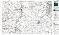
~ Pittsburgh West PA topo map, 1:100000 scale, 30 X 60 Minute, Historical, 1986, updated 1986
Pittsburgh West, Pennsylvania, USGS topographic map dated 1986.
Includes geographic coordinates (latitude and longitude). This topographic map is suitable for hiking, camping, and exploring, or framing it as a wall map.
Printed on-demand using high resolution imagery, on heavy weight and acid free paper, or alternatively on a variety of synthetic materials.
Topos available on paper, Waterproof, Poly, or Tyvek. Usually shipping rolled, unless combined with other folded maps in one order.
- Product Number: USGS-5331976
- Free digital map download (high-resolution, GeoPDF): Pittsburgh West, Pennsylvania (file size: 20 MB)
- Map Size: please refer to the dimensions of the GeoPDF map above
- Weight (paper map): ca. 55 grams
- Map Type: POD USGS Topographic Map
- Map Series: HTMC
- Map Verison: Historical
- Cell ID: 68158
- Scan ID: 223774
- Imprint Year: 1986
- Aerial Photo Year: 1982
- Edit Year: 1986
- Datum: NAD27
- Map Projection: Universal Transverse Mercator
- Planimetric: Yes
- Map published by United States Geological Survey
- Map Language: English
- Scanner Resolution: 600 dpi
- Map Cell Name: Pittsburgh West
- Grid size: 30 X 60 Minute
- Date on map: 1986
- Map Scale: 1:100000
- Geographical region: Pennsylvania, United States
Neighboring Maps:
All neighboring USGS topo maps are available for sale online at a variety of scales.
Spatial coverage:
Topo map Pittsburgh West, Pennsylvania, covers the geographical area associated the following places:
- Rabbit Hill - Edgewood - Mill Acres - Green Acres - Westwood - Claremont - Springdale - Morningview - Sugar Hill - Glendwell - Hagan Addition - Good Intent - Mount de Chantal - Terminal Junction - Linden - Zediker - Broadlawn Highlands - Morgan Hill - Valley Grove - Sun Valley - Esplen - Wylandville - Robyville - Mingo Junction - Weems - Upland Heights - Science Hill - Forest View - Lincoln Hill - Essen - Fernwood - Mozart Meadows - Upper Saint Clair - Canellas Park - Sturgeon - Swickards Addition - Export - Washington Junction - Conger - Frankfort Springs - Boyer - West Zollarsville - Reissing - Saint Clairsville - Burgettstown - Blackhorse (historical) - Brevard - Pittsburgh Junction - Pattersons Mill - California Kirkbride - West Amity - West Liberty - Wolf Estates - Crabapple - Germano - Buffalo - Brighton Heights - Atlasburg - East Springfield - Old Zollarsville - Martins Ferry - Triadelphia - Cadiz Junction - Oakmont Hills - Warwood Terrace - Narva - Pennsbury Village - Venetia - Downtown - Wallace Heights - Kolmont - Noblestown - Bishop - Ellsworth - Stuart Manor - Winifred Knoll - Twilight - West Liberty - Rich Hill - Hopewell - Cork - Fells (historical) - Log Pile - Library Junction - Amsterdam - Mount Washington - Cecil - Logrow - Champion - Banksville - Bloomingdale - McDonald - Allison Park - Gale - Shingiss - Fairfield - Bavington - Parkview - Cedar Rocks - Bethlehem
- Map Area ID: AREA40.540-81-80
- Northwest corner Lat/Long code: USGSNW40.5-81
- Northeast corner Lat/Long code: USGSNE40.5-80
- Southwest corner Lat/Long code: USGSSW40-81
- Southeast corner Lat/Long code: USGSSE40-80
- Northern map edge Latitude: 40.5
- Southern map edge Latitude: 40
- Western map edge Longitude: -81
- Eastern map edge Longitude: -80


