
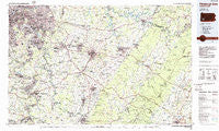
~ Pittsburgh East PA topo map, 1:100000 scale, 30 X 60 Minute, Historical, 1986, updated 1986
Pittsburgh East, Pennsylvania, USGS topographic map dated 1986.
Includes geographic coordinates (latitude and longitude). This topographic map is suitable for hiking, camping, and exploring, or framing it as a wall map.
Printed on-demand using high resolution imagery, on heavy weight and acid free paper, or alternatively on a variety of synthetic materials.
Topos available on paper, Waterproof, Poly, or Tyvek. Usually shipping rolled, unless combined with other folded maps in one order.
- Product Number: USGS-5331970
- Free digital map download (high-resolution, GeoPDF): Pittsburgh East, Pennsylvania (file size: 20 MB)
- Map Size: please refer to the dimensions of the GeoPDF map above
- Weight (paper map): ca. 55 grams
- Map Type: POD USGS Topographic Map
- Map Series: HTMC
- Map Verison: Historical
- Cell ID: 68157
- Scan ID: 223765
- Imprint Year: 1986
- Woodland Tint: Yes
- Aerial Photo Year: 1983
- Edit Year: 1986
- Datum: NAD27
- Map Projection: Universal Transverse Mercator
- Planimetric: Yes
- Map published by United States Geological Survey
- Map Language: English
- Scanner Resolution: 600 dpi
- Map Cell Name: Pittsburgh East
- Grid size: 30 X 60 Minute
- Date on map: 1986
- Map Scale: 1:100000
- Geographical region: Pennsylvania, United States
Neighboring Maps:
All neighboring USGS topo maps are available for sale online at a variety of scales.
Spatial coverage:
Topo map Pittsburgh East, Pennsylvania, covers the geographical area associated the following places:
- Rocktown - Herminie - Lincoln Park - Belmar - Pierce - Dutch Hill - Palmertown - Eureka - Allenport - Smith - McCullough - Albany - Pleasant Valley - Dravosburg - Hazel Kirk - Shadyside - Boltz - Van Voorhis - Fairmount - Elben - Frick Park - New Eagle - Maxwell - East Monongahela - Middletown - Fredericktown - Highland - Mansville - West Brownsville - Pleasant Hill - Kennywood Park - Keystone - Stewart - Coulter - Hahntown - Emblem - Forbes Road - Basforth Acres - Denbo - Clairton - Nellie - Greenwald - Vanderbilt - Bruceton - Humphreys - Saint Vincent Shaft - Redds Mill - Otto - Hostetter - East Pittsburgh - Bessemer - Radebaugh - Edna Number Two - Monessen - Jefferson Hills - Allenvale - Woodglen - Kier - Darragh - United - Brentwood - Laughlintown - Hill Distrct - Trafford - Maple Grove - Harrison City - Speers - Wall - Oak Hill - Indian Head - Baldwin - Centerville - Rankin - Grapeville - Centerville - Overbrook - West Newton - Newtown - Uptown - Smithton - Bridgeport - Brenizer - Champion - Pitcairn - Whites Hill - Blairsville - Fairfield Heights - Southwest - Standard Shaft - Thornwood - Sharrertown - Gibson - Broad Ford - Eastvue - Mount Olive - Stanton Heights - Lockview - Cochrans Mill - Lynnwood - Horning
- Map Area ID: AREA40.540-80-79
- Northwest corner Lat/Long code: USGSNW40.5-80
- Northeast corner Lat/Long code: USGSNE40.5-79
- Southwest corner Lat/Long code: USGSSW40-80
- Southeast corner Lat/Long code: USGSSE40-79
- Northern map edge Latitude: 40.5
- Southern map edge Latitude: 40
- Western map edge Longitude: -80
- Eastern map edge Longitude: -79


