
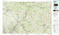
~ Indiana PA topo map, 1:100000 scale, 30 X 60 Minute, Historical, 1983, updated 1983
Indiana, Pennsylvania, USGS topographic map dated 1983.
Includes geographic coordinates (latitude and longitude). This topographic map is suitable for hiking, camping, and exploring, or framing it as a wall map.
Printed on-demand using high resolution imagery, on heavy weight and acid free paper, or alternatively on a variety of synthetic materials.
Topos available on paper, Waterproof, Poly, or Tyvek. Usually shipping rolled, unless combined with other folded maps in one order.
- Product Number: USGS-5331962
- Free digital map download (high-resolution, GeoPDF): Indiana, Pennsylvania (file size: 30 MB)
- Map Size: please refer to the dimensions of the GeoPDF map above
- Weight (paper map): ca. 55 grams
- Map Type: POD USGS Topographic Map
- Map Series: HTMC
- Map Verison: Historical
- Cell ID: 67704
- Scan ID: 171914
- Imprint Year: 1983
- Woodland Tint: Yes
- Aerial Photo Year: 1977
- Edit Year: 1983
- Datum: NAD27
- Map Projection: Universal Transverse Mercator
- Map published by United States Geological Survey
- Map Language: English
- Scanner Resolution: 600 dpi
- Map Cell Name: Indiana
- Grid size: 30 X 60 Minute
- Date on map: 1983
- Map Scale: 1:100000
- Geographical region: Pennsylvania, United States
Neighboring Maps:
All neighboring USGS topo maps are available for sale online at a variety of scales.
Spatial coverage:
Topo map Indiana, Pennsylvania, covers the geographical area associated the following places:
- Northvue - Lookabough Corners - North Washington - Rosston - Fowler Heights - Loop - Valencia - Lawsonham - Blanchard - Mineral Spring - Harmarville - Milligantown - Georgetown - Lenape Heights - Kiskimere - Wick City - Fenelton - Salina - Oak Hills - Ford Cliff - Montrose Hill - Van Dykes - Fawn Haven Number One - Kittanning - Atwood - Ben Avon - Onberg - Houseville - Girty - Elfinwild - Allison Park - Garretts Run - Curtisville - Riverview - Rossmoyne - Weimer - Leechburg - Cherry Lane - Shelocta - Wittmer - Fordham - Undercliff - Magill Heights - Sharpe Hill - Etna - Slabtown - Seminole - Spaces Corners - Elderton - West Ford City - Birdville - Sligo - Garvers Ferry - Coyleville - North Oakland - Oak Tree - Sportsburg - East Kittanning - Edmon - Laneville - Meredith - Schenley - Smeltzer - Fox Chapel - Gastown - West Valley - Springdale - Forks Church - Lardintown - Bagdad - Hamilton - Penn Hills - Charlestown - Blanco - Home - Van Buren - Reesedale - Idaho - Lucerne Mines - Iselin - McHaddon - Pyrra - Top - Gibsonia - Markle - Cochrans Mills - Dime - Rockville - Rockdale - Wells - Muff - Blanket Hill - Fairview Heights - Crete - Chevy Chase Heights - Pleasant View - Saint Charles - Denton - Tearing Run - Eddyville
- Map Area ID: AREA4140.5-80-79
- Northwest corner Lat/Long code: USGSNW41-80
- Northeast corner Lat/Long code: USGSNE41-79
- Southwest corner Lat/Long code: USGSSW40.5-80
- Southeast corner Lat/Long code: USGSSE40.5-79
- Northern map edge Latitude: 41
- Southern map edge Latitude: 40.5
- Western map edge Longitude: -80
- Eastern map edge Longitude: -79


