
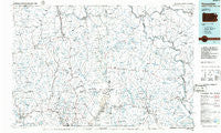
~ Honesdale PA topo map, 1:100000 scale, 30 X 60 Minute, Historical, 1986, updated 1986
Honesdale, Pennsylvania, USGS topographic map dated 1986.
Includes geographic coordinates (latitude and longitude). This topographic map is suitable for hiking, camping, and exploring, or framing it as a wall map.
Printed on-demand using high resolution imagery, on heavy weight and acid free paper, or alternatively on a variety of synthetic materials.
Topos available on paper, Waterproof, Poly, or Tyvek. Usually shipping rolled, unless combined with other folded maps in one order.
- Product Number: USGS-5331960
- Free digital map download (high-resolution, GeoPDF): Honesdale, Pennsylvania (file size: 16 MB)
- Map Size: please refer to the dimensions of the GeoPDF map above
- Weight (paper map): ca. 55 grams
- Map Type: POD USGS Topographic Map
- Map Series: HTMC
- Map Verison: Historical
- Cell ID: 67679
- Scan ID: 222874
- Imprint Year: 1986
- Aerial Photo Year: 1981
- Edit Year: 1986
- Datum: NAD27
- Map Projection: Universal Transverse Mercator
- Planimetric: Yes
- Map published by United States Geological Survey
- Map Language: English
- Scanner Resolution: 600 dpi
- Map Cell Name: Honesdale
- Grid size: 30 X 60 Minute
- Date on map: 1986
- Map Scale: 1:100000
- Geographical region: Pennsylvania, United States
Neighboring Maps:
All neighboring USGS topo maps are available for sale online at a variety of scales.
Spatial coverage:
Topo map Honesdale, Pennsylvania, covers the geographical area associated the following places:
- Cooper Corners - Fairmount - Tyler Hill - East Lemon - Prompton - Long Eddy - Brushville - Brooklyn - Rutledgedale - Obernburg - Brookdale - Westcolang - Carbondale - Luzerne - Parkvale - Lindaville - Factoryville - Osterhout - Sherman - Deckertown - Cochecton - Fallsdale - Jefferson Junction - Fernwood - Hilltown - Chiloway - Elk Lake - Dimock - Hillsdale - Orson - East Ararat - Cherry Ridge - East Branch - Kaiserville - Waverly - Smiley - Laurella - French Woods - Beach Lake - Bethany - Union Dale - Oakland - Indian Orchard - Avery - East Jermyn - Gibson - Jermyn - Tallmanville - Beech Grove - Green Grove - Rudes Corner - Stanfordville - Stevens Point - Lymanville - La Plume - East Lenox - West Nicholson - Brookside - Autumn Leaves - Dyberry - Chapman Lake - Torrey - Dundaff - North Jackson - Milanville - West Clifford - West Lenox - Walls Corners - Jackson - Glenburn - Bardwell - Tirzah - East Honesdale - Stalker - Tusten - Lakeview - Lakeside - Fermoy - Harford - White Mills - Tompkinsville - Dixon - Wrighter Corner - Creamton - Methol - Humphreysville - Hickory Grove - Conklin Hill - Steene - Pleasant Valley - Tyler - Snows Mill - Aldenville - Forest Lake - East Cochecton - Lewis Corners - Hop Bottom - Tanners Falls - Fisk Mill - Atco
- Map Area ID: AREA4241.5-76-75
- Northwest corner Lat/Long code: USGSNW42-76
- Northeast corner Lat/Long code: USGSNE42-75
- Southwest corner Lat/Long code: USGSSW41.5-76
- Southeast corner Lat/Long code: USGSSE41.5-75
- Northern map edge Latitude: 42
- Southern map edge Latitude: 41.5
- Western map edge Longitude: -76
- Eastern map edge Longitude: -75


