
~ Clearfield PA topo map, 1:100000 scale, 30 X 60 Minute, Historical, 1983, updated 1984
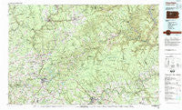
Clearfield, Pennsylvania, USGS topographic map dated 1983.
Includes geographic coordinates (latitude and longitude). This topographic map is suitable for hiking, camping, and exploring, or framing it as a wall map.
Printed on-demand using high resolution imagery, on heavy weight and acid free paper, or alternatively on a variety of synthetic materials.
Topos available on paper, Waterproof, Poly, or Tyvek. Usually shipping rolled, unless combined with other folded maps in one order.
- Product Number: USGS-5331948
- Free digital map download (high-resolution, GeoPDF): Clearfield, Pennsylvania (file size: 27 MB)
- Map Size: please refer to the dimensions of the GeoPDF map above
- Weight (paper map): ca. 55 grams
- Map Type: POD USGS Topographic Map
- Map Series: HTMC
- Map Verison: Historical
- Cell ID: 67307
- Scan ID: 172305
- Imprint Year: 1984
- Woodland Tint: Yes
- Aerial Photo Year: 1977
- Edit Year: 1983
- Datum: NAD27
- Map Projection: Universal Transverse Mercator
- Map published by United States Geological Survey
- Map Language: English
- Scanner Resolution: 600 dpi
- Map Cell Name: Clearfield
- Grid size: 30 X 60 Minute
- Date on map: 1983
- Map Scale: 1:100000
- Geographical region: Pennsylvania, United States
Neighboring Maps:
All neighboring USGS topo maps are available for sale online at a variety of scales.
Spatial coverage:
Topo map Clearfield, Pennsylvania, covers the geographical area associated the following places:
- Kersey - Keewaydin - Brandy Camp - Winterburn - Lanes Mills - Rathmel - Sulger (historical) - Warsaw - Smith Mills - Du Bois - Beechton - Helen Mills - Allens Mills - Ridgway - Barrett - Paine - Greenville - Home Camp - Sinnemahoning - Hoovertown - Saint Marys - Walsh - Toby - Gillingham - Anderson Creek - McMinns Summit - Fairview - Baney Settlement - Leonard - Mix Run - Fuller - Needful - Croft - Clearfield - Beechtree - Egypt - Dagus - Rolfe - Spruce - Prescottville - Palestine - Detwood - Blowtown - Iselin Heights - Brockway - Walton - Smithtown - Surveyor - Karthaus - Horton City - Hyde - Gallows Harbor - Schoffner Corner - Desire - Reitz - Cartwright - Drifting - West Creek - Coal Hollow - Erie Junction - Guenot Settlement - Tapawingo - Shaffer - Hazen - Sumerson - Penfield - Coal Glen - Five Points - Swissmont - German Settlement - Squab Hollow - Stump Creek - Oklahoma - Adrian Furnace - Medix Run - Montmorenci - Owls Nest - Stanley - Hallton - Berge Run - Brockport - Glendale (historical) - Driftwood - Troutville - Sterling Run - Jericho - Pardus - C and M Junction - Narrows Creek - Emerickville - Egypt - Earlyville - Battle Hollow - Hicks Run - Kerr Addition - Hollywood - Anita - Lynchville - Portland Mills - Harveys Run
- Map Area ID: AREA41.541-79-78
- Northwest corner Lat/Long code: USGSNW41.5-79
- Northeast corner Lat/Long code: USGSNE41.5-78
- Southwest corner Lat/Long code: USGSSW41-79
- Southeast corner Lat/Long code: USGSSE41-78
- Northern map edge Latitude: 41.5
- Southern map edge Latitude: 41
- Western map edge Longitude: -79
- Eastern map edge Longitude: -78


