
~ Carlisle PA topo map, 1:100000 scale, 30 X 60 Minute, Historical, 1984, updated 1989
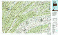
Carlisle, Pennsylvania, USGS topographic map dated 1984.
Includes geographic coordinates (latitude and longitude). This topographic map is suitable for hiking, camping, and exploring, or framing it as a wall map.
Printed on-demand using high resolution imagery, on heavy weight and acid free paper, or alternatively on a variety of synthetic materials.
Topos available on paper, Waterproof, Poly, or Tyvek. Usually shipping rolled, unless combined with other folded maps in one order.
- Product Number: USGS-5331946
- Free digital map download (high-resolution, GeoPDF): Carlisle, Pennsylvania (file size: 28 MB)
- Map Size: please refer to the dimensions of the GeoPDF map above
- Weight (paper map): ca. 55 grams
- Map Type: POD USGS Topographic Map
- Map Series: HTMC
- Map Verison: Historical
- Cell ID: 67237
- Scan ID: 223515
- Imprint Year: 1989
- Woodland Tint: Yes
- Photo Inspection Year: 1985
- Aerial Photo Year: 1980
- Edit Year: 1984
- Datum: NAD27
- Map Projection: Universal Transverse Mercator
- Map published by United States Geological Survey
- Map Language: English
- Scanner Resolution: 600 dpi
- Map Cell Name: Carlisle
- Grid size: 30 X 60 Minute
- Date on map: 1984
- Map Scale: 1:100000
- Geographical region: Pennsylvania, United States
Neighboring Maps:
All neighboring USGS topo maps are available for sale online at a variety of scales.
Spatial coverage:
Topo map Carlisle, Pennsylvania, covers the geographical area associated the following places:
- Keystone - Lees Cross Roads - Rose Glen - Upper Mill - Longsdorf - Pleasant View - Walnut Grove - New Lancaster - Newburg - Dromgold - Neelyton - McVeytown - Coyle - Bailey - Kerrsville - McCoysville - Allen - Erly - Centre - Williams Grove - Springville - Aughwick - Krause - Newton Hamilton - Shade Gap - Page (historical) - Hatton - Metal - Perulack - Grieder - Uniontown - Willow Hill - Middle Spring - Birdville - Amberson Valley Estates - Walnut Bottom - Gardners - Locust Point - Upper Strasburg - Ardenheim - Carlisle - Little Kansas - Nyesville - Knobsville - Mount Holly Springs - Mount Tabor - Brandtsville - McKee - Myerstown - Bridgeport - Culbertson - Peru Mills - Blairs Mills - Cowans Village - Mapleton - Duncannon - Spears Grove - Liebys Trailer Park - Entlerville - East Waterford - Boggstown - Acker - Blosserville - Pogue - Shermans Dale - Carlisle Junction - Sunnyland - Kistler - Cross Keys - Cisna Run - Carroll Manor - Cumminsville - Huntsdale - Franklintown - Big Spring - Milltown - Doyles Mills - Leidighs - Sweetwater - Peach Glen - Maple Grove - Mount Hope - Mattawana - Loysville - Doylesburg - New Germantown - Bunker Hill - McCullochs Mills - White Rock Acres - Mainsville - Meadow Gap - Montsera - Reeds Gap - Mount Pleasant - Mentzer - Heberlig - Roxbury - Bears Crossroads - Tusculum - Mongul
- Map Area ID: AREA40.540-78-77
- Northwest corner Lat/Long code: USGSNW40.5-78
- Northeast corner Lat/Long code: USGSNE40.5-77
- Southwest corner Lat/Long code: USGSSW40-78
- Southeast corner Lat/Long code: USGSSE40-77
- Northern map edge Latitude: 40.5
- Southern map edge Latitude: 40
- Western map edge Longitude: -78
- Eastern map edge Longitude: -77


