
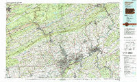
~ Allentown PA topo map, 1:100000 scale, 30 X 60 Minute, Historical, 1984, updated 1988
Allentown, Pennsylvania, USGS topographic map dated 1984.
Includes geographic coordinates (latitude and longitude). This topographic map is suitable for hiking, camping, and exploring, or framing it as a wall map.
Printed on-demand using high resolution imagery, on heavy weight and acid free paper, or alternatively on a variety of synthetic materials.
Topos available on paper, Waterproof, Poly, or Tyvek. Usually shipping rolled, unless combined with other folded maps in one order.
- Product Number: USGS-5331936
- Free digital map download (high-resolution, GeoPDF): Allentown, Pennsylvania (file size: 27 MB)
- Map Size: please refer to the dimensions of the GeoPDF map above
- Weight (paper map): ca. 55 grams
- Map Type: POD USGS Topographic Map
- Map Series: HTMC
- Map Verison: Historical
- Cell ID: 76776
- Scan ID: 223375
- Imprint Year: 1988
- Woodland Tint: Yes
- Visual Version Number: 1
- Aerial Photo Year: 1981
- Edit Year: 1984
- Datum: NAD27
- Map Projection: Universal Transverse Mercator
- Map published by United States Geological Survey
- Map Language: English
- Scanner Resolution: 600 dpi
- Map Cell Name: Allentown
- Grid size: 30 X 60 Minute
- Date on map: 1984
- Map Scale: 1:100000
- Geographical region: Pennsylvania, United States
Neighboring Maps:
All neighboring USGS topo maps are available for sale online at a variety of scales.
Spatial coverage:
Topo map Allentown, Pennsylvania, covers the geographical area associated the following places:
- Centreville - Fullerton - Lochland - North Catasauqua - Penn Allen - Klines Corner - Tadmor - Mountainville - Warren Glen - Bucksville - Hollywood - Arlington Knolls - Stines Corner - Hanoverville - Hancock - Kreidersville - Howertown - Brass Castle - Saylorsburg - Factoryville - Limeport - Oakdale - Jacobsburg (historical) - Middletown - Arlington Heights - Saegersville - Macada - Vera Cruz Station - Minesite - Palmerton East - Cherryville - Ironton - Amity - Emmaus - Tatamy - Bushkill Center - Aquashicola - Kempton - Apps - Hamilton Square - Kunkletown - Guthsville - Wennersville - Weiders Crossing - Cedarbrook County Home - Custer - Gruvertown - Bridgeville - Lockridge - Mertz Town - Grimville - Pleasant Valley - Leviston - Mechanicsville - Harpers - Durham - Weaversville - West Pen Argyl - Hokendauqua - Uhlersville (historical) - Northampton - Weidasville - Chapman - Old Sugar Loaf - Egypt - Mechanicsville - Greenawald - Monroe - McMichael - Old Orchard - Pattenburg - Krumsville - South Easton - Hemlock Glen - Leibeyville - Fogelsville - Dreibelbis - Haafsville - Lattimer - Macungie - Dry Tavern - Switzer - Lehighton - Youngsville - Mount Joy - Balliettsville - Dorset - Christian Corner - Belfast - Peters Store - Walnutport Acres - Walnut Acres - Ferndale - Notre Dame Hills - Klecknersville - Lockport - Stormville - McIlhaney - Tresckow - Unionville
- Map Area ID: AREA4140.5-76-75
- Northwest corner Lat/Long code: USGSNW41-76
- Northeast corner Lat/Long code: USGSNE41-75
- Southwest corner Lat/Long code: USGSSW40.5-76
- Southeast corner Lat/Long code: USGSSE40.5-75
- Northern map edge Latitude: 41
- Southern map edge Latitude: 40.5
- Western map edge Longitude: -76
- Eastern map edge Longitude: -75


