
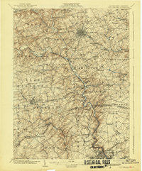
~ West Chester PA topo map, 1:62500 scale, 15 X 15 Minute, Historical, 1904, updated 1943
West Chester, Pennsylvania, USGS topographic map dated 1904.
Includes geographic coordinates (latitude and longitude). This topographic map is suitable for hiking, camping, and exploring, or framing it as a wall map.
Printed on-demand using high resolution imagery, on heavy weight and acid free paper, or alternatively on a variety of synthetic materials.
Topos available on paper, Waterproof, Poly, or Tyvek. Usually shipping rolled, unless combined with other folded maps in one order.
- Product Number: USGS-5331834
- Free digital map download (high-resolution, GeoPDF): West Chester, Pennsylvania (file size: 9 MB)
- Map Size: please refer to the dimensions of the GeoPDF map above
- Weight (paper map): ca. 55 grams
- Map Type: POD USGS Topographic Map
- Map Series: HTMC
- Map Verison: Historical
- Cell ID: 64403
- Scan ID: 222475
- Imprint Year: 1943
- Survey Year: 1901
- Datum: Unstated
- Map Projection: Polyconic
- Map published by United States Geological Survey
- Map Language: English
- Scanner Resolution: 600 dpi
- Map Cell Name: West Chester
- Grid size: 15 X 15 Minute
- Date on map: 1904
- Map Scale: 1:62500
- Geographical region: Pennsylvania, United States
Neighboring Maps:
All neighboring USGS topo maps are available for sale online at a variety of scales.
Spatial coverage:
Topo map West Chester, Pennsylvania, covers the geographical area associated the following places:
- Lamatan II - Ringfield - Arborlea - Dutts Mill - Painters Crossroads - Thornton - Dilworthtown - Quintynnes - Iron Gates - Rosedale - Brandon - Birmingham Estates - Cherrington - Guyencourt - Wylie Farms - Perth - Concord Hills - Windward - Wellington Hills - Cossart - Rockwood Hills - Dartmouth Woods II - Brandywood - Fern Hill - Bridlewood Farm - Westtown Park - Woodbine - Fairville - Goshen Terrace - Concordville - Westbrite - Allegiance - Shipley Heights - Green Hill - Clifton Park Manor - Welshire - York Towne - Bon Ayre - Alapocas - Elam - Painters Crossing - Chadds Ford Junction - Auburn Hills - Winterthur - Edenridge - Pleasant Grove - Limestone Hills - Brackenville Woods - Bellewood - Nanticoke Farms - Ainsley Woods - Mitchell Estates - Chadds Ford West - Hampton - Cossart Creek - Montchanin - Oakbourne - Penny Acres - Westtown Country Estates - Edgewood Hills - Birmingham Hunt - Saverys Mill - Oak Lane Manor - Pennyhill - Blue Ball - Brackenville - Fox Meadow - Clayton Meadows - Windon - Green Meadow - Northwood - Valley View - Williamhurst - Canterbury Hills - Ashwell - Brookfield - North Star Addition - Pennwood South - Westtown Acres - Green Manor Farm - Brandywine Hunt - Fair Acres Farm - Shellburne - Goshen Commons - West Wynn - Deerbrook I - Westgate Farms - Westtown Hillside - Coventry Village - Brookhill Farms - Glenside Farms - Westmount - Galewood - Twin Oaks - Concord Hunt - Hockessin - Oakwood Hills - Rockland - Wawaset Park - The Knolls of Birmingham
- Map Area ID: AREA4039.75-75.75-75.5
- Northwest corner Lat/Long code: USGSNW40-75.75
- Northeast corner Lat/Long code: USGSNE40-75.5
- Southwest corner Lat/Long code: USGSSW39.75-75.75
- Southeast corner Lat/Long code: USGSSE39.75-75.5
- Northern map edge Latitude: 40
- Southern map edge Latitude: 39.75
- Western map edge Longitude: -75.75
- Eastern map edge Longitude: -75.5


