
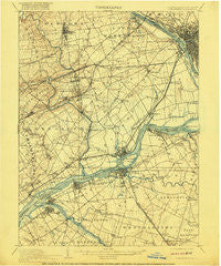
~ Burlington NJ topo map, 1:62500 scale, 15 X 15 Minute, Historical, 1906, updated 1916
Burlington, New Jersey, USGS topographic map dated 1906.
Includes geographic coordinates (latitude and longitude). This topographic map is suitable for hiking, camping, and exploring, or framing it as a wall map.
Printed on-demand using high resolution imagery, on heavy weight and acid free paper, or alternatively on a variety of synthetic materials.
Topos available on paper, Waterproof, Poly, or Tyvek. Usually shipping rolled, unless combined with other folded maps in one order.
- Product Number: USGS-5329554
- Free digital map download (high-resolution, GeoPDF): Burlington, New Jersey (file size: 7 MB)
- Map Size: please refer to the dimensions of the GeoPDF map above
- Weight (paper map): ca. 55 grams
- Map Type: POD USGS Topographic Map
- Map Series: HTMC
- Map Verison: Historical
- Cell ID: 51938
- Scan ID: 169838
- Imprint Year: 1916
- Edit Year: 1904
- Survey Year: 1898
- Datum: Unstated
- Map Projection: Unstated
- Map published by United States Geological Survey
- Map Language: English
- Scanner Resolution: 600 dpi
- Map Cell Name: Burlington
- Grid size: 15 X 15 Minute
- Date on map: 1906
- Map Scale: 1:62500
- Geographical region: New Jersey, United States
Neighboring Maps:
All neighboring USGS topo maps are available for sale online at a variety of scales.
Spatial coverage:
Topo map Burlington, New Jersey, covers the geographical area associated the following places:
- Quincy Hollow - Langhorne Gardens - Yardley - Riverton - Maple Beach - Prospect Park - Grundys Corner - Normandy - Longmead Farms - Holland - Bridgeboro - Cobalt Ridge - Mechanicsville - Plaza Park - Martins Beach - Hulmeville Terrace - Five Points - Holly Hill - Emilie - Bath Addition - Lakeside - Franklin Park - Violet Wood - Fergusonville - Bridgewater - Siles - Kinkora - East Burlington - Langhorne Terrace - Whitewood - Skin Corner - Hawthorne Park - Farnerville - Byberry - Union Landing - Pinewood - Farmbrook - Crabtree Hollow - Woodbourne - Morrisville - Edgewater Park - Indian Creek - Idlewood - Fairview - Neshaminy Heights - Garfield Park - Woodlane - Goldenridge - Maple Point - Edgely - Bustleton - Hillcrest - Burlington - Maple Shade - Dogwood Hollow - Bensalem - Saint Leonard - Twin Hill Park - Devon Close - Midway - Hulmeville - Modena Park - Garfield Park East - Neshaminy Hills - Bristol Terrace Number One - Bucktoe - North Park - La Trappe - Centre Plaza Shopping Center - Byberry - Oxford Valley - Greenbrook - Rancocas - Edge Hill - Parkland - Rockdale - Pennypacker Park - Kearney - Roebling - Stanwood - Delaire Landing - Roelofs - Langhorne - Somerset Park - Bellview - Cornwells Heights - Stevens - Janney - Mill Creek Falls - Fairless Junction - Deacons - Eddington - Red Cedar Hill - Crestmont Farms - Villas of Middletown - Florence - Unionville - Cornwell - Jacksonville - Thornridge
- Map Area ID: AREA40.2540-75-74.75
- Northwest corner Lat/Long code: USGSNW40.25-75
- Northeast corner Lat/Long code: USGSNE40.25-74.75
- Southwest corner Lat/Long code: USGSSW40-75
- Southeast corner Lat/Long code: USGSSE40-74.75
- Northern map edge Latitude: 40.25
- Southern map edge Latitude: 40
- Western map edge Longitude: -75
- Eastern map edge Longitude: -74.75


