
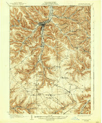
~ Bradford PA topo map, 1:62500 scale, 15 X 15 Minute, Historical, 1926, updated 1938
Bradford, Pennsylvania, USGS topographic map dated 1926.
Includes geographic coordinates (latitude and longitude). This topographic map is suitable for hiking, camping, and exploring, or framing it as a wall map.
Printed on-demand using high resolution imagery, on heavy weight and acid free paper, or alternatively on a variety of synthetic materials.
Topos available on paper, Waterproof, Poly, or Tyvek. Usually shipping rolled, unless combined with other folded maps in one order.
- Product Number: USGS-5329482
- Free digital map download (high-resolution, GeoPDF): Bradford, Pennsylvania (file size: 10 MB)
- Map Size: please refer to the dimensions of the GeoPDF map above
- Weight (paper map): ca. 55 grams
- Map Type: POD USGS Topographic Map
- Map Series: HTMC
- Map Verison: Historical
- Cell ID: 51724
- Scan ID: 170373
- Imprint Year: 1938
- Survey Year: 1924
- Datum: NAD
- Map Projection: Polyconic
- Map published by United States Geological Survey
- Map Language: English
- Scanner Resolution: 600 dpi
- Map Cell Name: Bradford
- Grid size: 15 X 15 Minute
- Date on map: 1926
- Map Scale: 1:62500
- Geographical region: Pennsylvania, United States
Neighboring Maps:
All neighboring USGS topo maps are available for sale online at a variety of scales.
Spatial coverage:
Topo map Bradford, Pennsylvania, covers the geographical area associated the following places:
- Big Shanty - Gifford - Middletown - Tuna - Coleville - Corwins Corners - Custer City - Bingham - Irishtown - Gilmore - Tallyho - McKean - Timbuck - Dallas City - Wolf Run - Cyclone - Fullerton - South Bradford - Riterville - Bradford - Sawyer City - Derrick City - Foster Brook - Allen - Bells Camp - Ormsby - Taintor - Guffey - Walkertown - Lafayette - Lewis Run - Gaffney - Howard - Degolia - Fairview Heights - Rew - Summit - Mount Alton - Bordell - Beechwood - Red Rock - Aiken - West Bradford - Simpson - Backus - Hazelton Mills
- Map Area ID: AREA4241.75-78.75-78.5
- Northwest corner Lat/Long code: USGSNW42-78.75
- Northeast corner Lat/Long code: USGSNE42-78.5
- Southwest corner Lat/Long code: USGSSW41.75-78.75
- Southeast corner Lat/Long code: USGSSE41.75-78.5
- Northern map edge Latitude: 42
- Southern map edge Latitude: 41.75
- Western map edge Longitude: -78.75
- Eastern map edge Longitude: -78.5


