
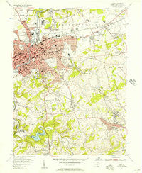
~ York PA topo map, 1:24000 scale, 7.5 X 7.5 Minute, Historical, 1954, updated 1957
York, Pennsylvania, USGS topographic map dated 1954.
Includes geographic coordinates (latitude and longitude). This topographic map is suitable for hiking, camping, and exploring, or framing it as a wall map.
Printed on-demand using high resolution imagery, on heavy weight and acid free paper, or alternatively on a variety of synthetic materials.
Topos available on paper, Waterproof, Poly, or Tyvek. Usually shipping rolled, unless combined with other folded maps in one order.
- Product Number: USGS-5329024
- Free digital map download (high-resolution, GeoPDF): York, Pennsylvania (file size: 12 MB)
- Map Size: please refer to the dimensions of the GeoPDF map above
- Weight (paper map): ca. 55 grams
- Map Type: POD USGS Topographic Map
- Map Series: HTMC
- Map Verison: Historical
- Cell ID: 72121
- Scan ID: 222627
- Imprint Year: 1957
- Woodland Tint: Yes
- Aerial Photo Year: 1952
- Field Check Year: 1954
- Datum: NAD27
- Map Projection: Polyconic
- Map published by United States Geological Survey
- Map Language: English
- Scanner Resolution: 600 dpi
- Map Cell Name: York
- Grid size: 7.5 X 7.5 Minute
- Date on map: 1954
- Map Scale: 1:24000
- Geographical region: Pennsylvania, United States
Neighboring Maps:
All neighboring USGS topo maps are available for sale online at a variety of scales.
Spatial coverage:
Topo map York, Pennsylvania, covers the geographical area associated the following places:
- Violet Hill - Beverly Hills - Jacobus - Elmwood - Marborough West - Woodland View - North York - Longview Heights - Canterbury - Southwood Hills - Idywyld - Robin Heights - Green Acres - North Hills - Farquhar Estates - Starview Heights - Gwendale - Waterford - Grantly Hills - Haines Acres - Leaders Heights - South Wood Hills - Ore Valley - Seven Acres - Valley Forge - Locust Grove - Grantley - Tri-Hill - South Ridge Estates - Fox Run - Willis Park - Amleyn Gardens - Strathcona Hills - Leafydale Terrace - McDonald Heights - Relay - Wilshire Hills - Appleton - Bellview Acres - Herman Heights - Homeland Gardens - Fair Acres - Arlington Park - Grandview Heights - Denton Terrace - Crestview Terrace - Yoe - York - Spry - Crestlyn Court - Chapel View - Randolph Park - Dallas Acres - Villa Green - Yorklyn - South View Acres - Hillcrest - Reynolds Mill - Oak Manor - Woodstream - Benroy - Hollywood Heights - Hill-n-Dale - Lightners Tract - Hillcroft - McClellan Heights - Fireside Terrace - Yorkshire - East Yoe - Green Hill - Rye - Park Village - Penn Oaks - Oakridge - Fayfield - Susquehanna Heights - Yorktown Homes - Brook Hill - Longstown - Dalvue - Sunset Terrace - East York - Carol Heights - Clearview Heights - Avondale - Springdale - Rosemount - Ridgefield - Skyline Heights - Chestnut Hill - Valley View - Golden (historical) - Dallastown - Manifold Manor - Wyndham Hills - Spring Plains - Stonewood Farms - Pleasureville - Stonybrook Heights - Stonybrook
- Map Area ID: AREA4039.875-76.75-76.625
- Northwest corner Lat/Long code: USGSNW40-76.75
- Northeast corner Lat/Long code: USGSNE40-76.625
- Southwest corner Lat/Long code: USGSSW39.875-76.75
- Southeast corner Lat/Long code: USGSSE39.875-76.625
- Northern map edge Latitude: 40
- Southern map edge Latitude: 39.875
- Western map edge Longitude: -76.75
- Eastern map edge Longitude: -76.625


