
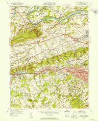
~ Valley Forge PA topo map, 1:24000 scale, 7.5 X 7.5 Minute, Historical, 1952, updated 1953
Valley Forge, Pennsylvania, USGS topographic map dated 1952.
Includes geographic coordinates (latitude and longitude). This topographic map is suitable for hiking, camping, and exploring, or framing it as a wall map.
Printed on-demand using high resolution imagery, on heavy weight and acid free paper, or alternatively on a variety of synthetic materials.
Topos available on paper, Waterproof, Poly, or Tyvek. Usually shipping rolled, unless combined with other folded maps in one order.
- Product Number: USGS-5328476
- Free digital map download (high-resolution, GeoPDF): Valley Forge, Pennsylvania (file size: 14 MB)
- Map Size: please refer to the dimensions of the GeoPDF map above
- Weight (paper map): ca. 55 grams
- Map Type: POD USGS Topographic Map
- Map Series: HTMC
- Map Verison: Historical
- Cell ID: 46569
- Scan ID: 222321
- Imprint Year: 1953
- Woodland Tint: Yes
- Aerial Photo Year: 1950
- Field Check Year: 1952
- Datum: NAD27
- Map Projection: Polyconic
- Map published by United States Geological Survey
- Map Language: English
- Scanner Resolution: 600 dpi
- Map Cell Name: Valley Forge
- Grid size: 7.5 X 7.5 Minute
- Date on map: 1952
- Map Scale: 1:24000
- Geographical region: Pennsylvania, United States
Neighboring Maps:
All neighboring USGS topo maps are available for sale online at a variety of scales.
Spatial coverage:
Topo map Valley Forge, Pennsylvania, covers the geographical area associated the following places:
- New Centerville - Continental Arms - Valley Forge Trailer Park - The Commons at Valley Forge - Shand Vassar - Aronwold - Glenn Rose - Chesterbrook - Valley Forge - Wyola - Powderhorn Knoll - Paoli Manor - Green Tree - Deepdale - Waynesborough Woods - Pawling Woods - Howellville - Chapel View Estates - Cannon Run West - Lafayette Park - Rennyson - Valley Forge Mountain North - Washington Park - Freedom View - Colonial Village - West Wayne - Glen Hardie - Perkiomen Junction - Meadows at Valley Forge - Village Builders - Paoli Woods Foxwood - Devon - Leopard Lakes - Duffryn Mawr - Daylesford Lake - Trinity House - Green Countrie Village - Valley Forge Meadows - Wetherills Corner - Crestwyck - Blackburn Farm - Brittains Corner - Sweet Briar - Treyburn - Paoli Gardens - Westover Club - Garden - Sunwood Farm - Valley Forge Woods - Valley Forge Mountain - Valley Forge Estates - Beidler Knoll - Dubarry Estates - Valley Greene - Abrahams - Strafford - Waterloo Mills - Kerwood - Waynewoods - Colonial Way - Whitehorse Farms - Lexton Woods - Cannon Run - Leopard Farms - Bull Tavern - Paoli - Wayne - Harrison Estate - Waynes Brooke - Devon Hunt - Buttonwood Farms - Betzwood - Glen Craig - Daylesford - Leopard - King of Prussia - David Estates - Weyhill - Berwyn - Hidden Valley - Saint Davids - Valley Forge Towers - Washingtons Crossing - Trent Manor - Paoli Road
- Map Area ID: AREA40.12540-75.5-75.375
- Northwest corner Lat/Long code: USGSNW40.125-75.5
- Northeast corner Lat/Long code: USGSNE40.125-75.375
- Southwest corner Lat/Long code: USGSSW40-75.5
- Southeast corner Lat/Long code: USGSSE40-75.375
- Northern map edge Latitude: 40.125
- Southern map edge Latitude: 40
- Western map edge Longitude: -75.5
- Eastern map edge Longitude: -75.375


